കണ്ണൂർ തീരത്തെ നശിപ്പിച്ച തിരകൾ. തെളിവായത് 18 6 4 ലെ മാപ്പ് .
Light house,Baby beach and steep Seashore
Kannur old and now Part 3
 |
| Modern Satellite image and 1864 map of the same area. |
The Main Road in the centre of this picture is SN park Road to Burnasseri.Government Guest house and Light house and sea view park are the highlights in this area. Kanathur kavu also can be visualised here. Most of high profile hoses and bungalows still in this area.
In a closer look, we can see little difference in the coastal boundary. Soil and hard laterite rock eroded in the course of time and hence the changes.
Light house
 The Cannanore Lighthouse near the Sea View Park is another place of interest. The first lighthouse at Kannur was built at St. Angelo Fort in, a system of hoisting a lantern with an oil wick lamp was introduced in 1843 by the British . A masonry pedestal was constructed in 1903 on the rampart of the fort and a double wick oil lamp inside the 4th order dioptric lens and lantern with arrangement for occultation was placed on this pedestal. The light was shifted in 1939 on to a 16 metre steel trestle erected on the northern bastion of the Fort. The steel trestle can still be seen today at the Fort.The light was made available during fair seasons only, from September to May every year.Over the years, the lighthouse was renovated by a flashing light with 10 second character running on DA gas in 1948 and it was moved to its current location. This light remained in operation till the new lighthouse tower was constructed at the present location during 1975-76.The lighthouse is still in use.
Photo courtesy :SSC forum Kannur

Yes. not a mistake, that half build look building was the lighthouse in 1948 in the present site. Photo on 1948.
This light remained in operation till the new lighthouse tower was constructed at the same location during 1975-76. 
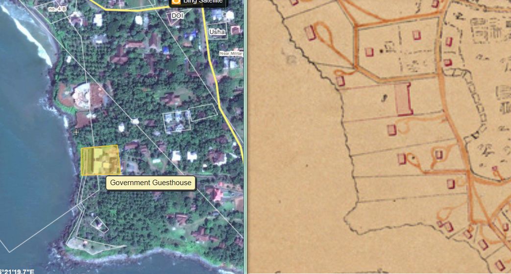
Modern Satellite image and 1864 map of the same area. Check-in Bing map: the erosion along the coastline is evident.

Walkway of beach: Photo courtesy :SSC forum Kannur thread

Goverment Guest house : Photo courtesy :SSC 


Title:Cannanore: beautiful north beach looking south."
Creator: Klein & Peyerl, Madras, India
Date: 01.01.1921-31.12.1940
Check this photo onlooking Baby beach and farther the fort itself. you may miss the lighthouse,because it ws non exist before 1948
European Hospital


The Position of Military hospital has been recorded as European Hospital in old Map.Working from old map, and by using proportions, it is possible to mark up a modern satellite photo with European Hospital might have been situated. Same building remains in same place, wit almost same functions.


The military hospital has been recorded as European Hospital. 

Obviously, there is a separation between Europeans and Local Indians in Medical Services. A General hospital for Native public was available near old Kannur city and Church. Presently that building and area are known as District HQ hospital,Kannur. I believe this church is mostly used for the native Christians only. Europeans had separate churches at Bernassery. I will give the photos in coming posts
Here, behind Bernasseri area again we can notice the effect of erosion and land mass is reduced as compare by the old map. There were houses between the road and coastline, on Mascot hotel road.

Mascot Hotel : Photo courtesy :SSC forum Kannur thread.
Baby Beach
Baby Beach is so called because it is smaller than its larger neighbour, Payyambalam Beach. The baby beach is part of the Cannanore Cantonment and accesses restricted.

Title :Shore in Calicut. Sea Compound Creator: unknown dated :1901
But I believe this photo was taken not from Calicut, but from the same location of Kannur.compare above photo of 1921

The lighthouse In the opposite angle, present

Compare the road and coastline in both images. Near Mascot hotel, and Baby beach the road running so close to the seashore, that underlines there is a severe attack of waves to land here. If this happens again in the next 200 years, Mascot hotel will not have a land to occupy.


But think about Mappila bay port and the problem of sand accumulation in port. May be soil from these sites slowly brought to the port. It is evident that the barrier is constructed in a non-scientific way. The sand and soil also contributes to the depth problem. We will discuss this all in the next posts.

Links of Kannur Interest:
this site is a really helpful one..!
ReplyDeletewonderful photos..beautiful blog
Its really informative..!`
Thank you very much for the information!!! :) :) :) Its great to know lot from your blog, keep posting more articles with good pictures. Definetly your blog is a sharing with friends type. Meanwhile I will also get to lots of latest Kerala news in malayalam from this new blog. Have a Good Day!
ReplyDelete