This is a detailed study of the available Maps of Malabar Cost. I just impreseed that my land Malabar-belongs a target of Europeans for spices and Trade in ancient periods.I can assume how much struggled they in that periods. All the major explorations and discoveries of new continets and numerous islands caused by my native land's attractive power.
I tried to collect all the informations of the images, Maps and depictions as much possible. All pictures are in a chronological order . Click the images for a larger view.
Kallivalli
Malabar_Map Exploration Routes - un dated
7th Century AD-Malabar Coast – Malabar 0700 Chinese Trade ROUTES
Malabar_1400_Trade Routes
Malabar_1498_Malay Archipelago
1513
DATE NOTE KNOWN TO ME
[An early woodcut bird-eye's view of the town of Calicut. India] Plant et Figure de la riche cit� de Calecut en la premiere Inde.
Author: Belleforest, F. de.
PlaceAndYear: Paris, 1575.
Description: Francois de Belleforest (1530-1583). Edited a French edition of Sebastian M�nster's 'Cosmography', named 'La Cosmographie universelle', 1575. An early woodcut bird-eye's view of the town of Calicut as seen from the sea, with ships in the foreground and right a ship's yard.
PAGE 1064 of Cosmographia" (1544) by Sebastian Münster gives basic facts on India. Most of
Münster's text is based on Strabo's Geography. In Book XV, "On India,"
Strabo writes:
"India is bounded on the north from
Ariana to the eastern sea, by the extremities of the Taurus, which by the
natives are severally called 'Paropamisus' and 'Emodus' and 'Imaus' and other
names, but by the Macedonians 'Caucasus'; on the west by the Indus River; but
the southern and eastern sides, which are much greater than the other two,
extend out into the Atlantic sea, and thus the shape of the country becomes
rhomboidal, each of the greater sides exceeding the opposite side by as much as
three thousand stadia, which is the same number of stadia by which the cape
common to the eastern and southern coast extends equally farther out in either
direction than the rest of the shore. Now the length of the western side from
the Caucasian Mountains to the southern sea is generally called thirteen
thousand stadia, I mean along the Indus River to its outlets, so that the the
opposite side, the eastern, if one adds the thousand of the cape, will be
sixteen thousand stadia. These, then, are the minimum and maximum breadths of
the country."

Probably the earliest depiction of Canonore, from 1572 Date: first Latin edition of volume I was published in 1572. After: an
unidentified Portuguese manuscript."
"Calecut Nuova Tavola" by Girolamo
Ruscelli, Venice, 1574
horizontal Malabar Coast miniature map by Abraham Ortelius, Antwerp, c.1580,
from the Epitome Theatri Orteliani
*"Guzurat Narsinga," 1588 (with modern hand
coloring
1598
| |
|
| |
|
| |
|
| | |
| |
|
| |
|
| |
Malabar_1600_Map
Malabar_1600_Map2
Ortelius's "Theatrum Orbis Terrarum," Latin edition of 1603 (with later hand coloring)
Mercator's "India Orientalis," Amsterdam, [engraved 1606]
Malabar_1608_Dutch Map
Malabar_1609_Bertius
Malabar_1609_LANGENES B
A view from a Portuguese atlas, 1630 mangalore
1638
The military system of the Dutch East India Company
1655 - 1663.
To the right we see the Ghats mountain range, separating the Malabar coast from the rest of the Indian mainland. The top leftmost island is Baypin. Right underneath we see Cochin (‘ Coetsjien’), and slightly further south Purracad (‘Porca’).The map also nicely shows the backwaters connecting the various Malabarese cities, which made isolation of Cochin highly problematic. Just south of the backwaters we see Quilon (‘Coylan’). Taken from Nieuhoff and displaying the situation around the time of the siege.

Malabar_1672_Map_Philip Baldaeus
Anique Map, Goa, Malabar Coast , India, by Baldaeus, 1672
Antique map of the Portuguese trading post Goa,Malabar coast,India, printed in 1672 for Baldaeus' work 'A true and exact description of the most celebrated East-India coasts of Malabar and Coromandel and also of the Isle of Ceylon', published in Amsterdam in 1672 by Jansssonius van Waasberge en van Someren. The upper part shows a city view and there is a cartouche identifying 43 buildings.
A miniature map from Pierre Duval's "Geographiae Universalis," 1679 (with
modern hand coloring)
Nieuhoff's early depictions of Malabarians,
1703
A Malabar Showing tricks with Serpents Nieuhof 1682
|

A Malabar Man and Woman Nieuhof 1682
Malabar_1702
Nieuhof's Audience with ye Queen of Koylang [Quilon]," from "Mr John Nieuhoff's
remarkable voyages & travels into ye best provinces of ye West and East
Indies", printed for Awnsham and John Churchill at the Black Swan in Pater
Noster Row, London, 1703
1703
Cananoor. 1709.
Author: Braam, J. van / G. onder de Linden.
PlaceAndYear: Amsterdam, 1728.
Description: From Francois Valentyn's '' Oud en Nieuw Oost Indien', part V : Beschryving van Coromandel, Pegu, Arrakan, Bengale, Mocha,…Persien...Malakka..Sumatra...Ceylon.A plan of the Dutch factory of Cananoor on the Malabar coast (Kerala). Ref.: Gole, India within the Ganges, 49.9.1
1720 Title: Carte du Golfe de Bengale,
Mer de Indes, et Riviere du Gange, Avec les Pais et Iles d'alentour, Savoir les
Cotes de Malabar, Cormandel, Ile de Ceylon, Les Maldives . . .
French map of South India showing ports and their controllers Guillaume de Lisle, 1723, Carte des Cotes de Malabar et de Coromandel - source: David Rumsey collection
Malabar_1724_Coromandel_VALENTIJN
1730
Map of peninsular India, with excellent detail for the Malabar and Coromandel
coasts. The colonial possessions of the English, Dutch and Portuguese are
indicated. The map is based on Bouchet’s maps of 1719, the most current of the
time. However, some notable inaccuracies remain, such as the mythical river
Ganga shown north of Orissa.
From a map of the Malabar and Coromandel Coasts by
Guillaume de l'Isle, Amsterdam, 1733
HOMANN HEIRS. - Peninsula Indiae Malabar Coromandel Ceylon., published in Nuremberg 1733.
Johann Baptist Homann's well-engraved map of southern India and Ceylon.
Johann Baptist Homann (1663-1724) was a German engraver and publisher, who established himself and his family as perhaps the most famous German map publishers. Following his death in 1724, the business continued under the name Homann Heirs . This Homann map is finely engraved, and in original wash colour with a coloured cartouche.
"La ville Cananor," from J. F. LaFitau,
'Histoire des Decouvertes et Conquestes des Portugais', Paris, 1733
map by Bellin, 1740, with original hand coloring
From a very detailed map by J. Covens and C.
Mortier: 'Carte D'Une Partie Des Indes Orientales, Etats Du Mogol Les Côtes De
Malabar Et De Coromandel &c. : dressée sur les Relations les plus
nouvelles', Amsterdam: c.1740
The frontispiece of vol. 3 of Churchill's 'A
Collection of Voyages and Travels', London, 1744-52
*"The City of Cananor" by Philip Baldaeus, 1744
(1672)*
The Malabar
Coast, from 'The True and Exact Description of the Most Celebrated East-India
Coast of Malabar and Choromandel as also of the Island of Ceylon' by Philip
Baldaeus, 1744 (first printed in 1672)
Malabar Bowen Map - Netherlands 1747 - Ramancoil
[antique plan of the town of Madras, India.] Plan de Madras et du Fort St. Georges.
1750.
Description: Jaques Nicolas Bellin (1702-720) was the most important French hydrographer of the 18th century. Sea-atlas 'Hydrographique Francais' , 1756-65, atlas to accompany Prevost d' Exile's ' Histoire. des Voyages', 1738-75. Nicolas Bellin's plan of the town of Madras. Ref.: Gole, India within the Ganges, 61.11.1

Ville de Cananor," a view from *PREVOST*, 1751; compare
*"The City of Cananor" by Philip Baldaeus, 1744 (1672
A view from 'De Zee en Land-Caarten... van
oost-indien' by the Van Keulen family, 1752
Bellin, 1752, with original hand-coloring: a detailed look at the area between
Bombay and Goa
Malabar_1752
antique plan of the town of Cochin, Malabar
PlaceAndYear: Amsterdam, c. 1755.
Description: Jaques Nicolas Bellin (1702-720) was the most important French hydrographer of the 18th century. Sea-atlas 'Hydrographique Francais' , 1756-65, atlas to accompany Prevost d' Exile's ' Histoire. des Voyages', 1738-75. Nicolas Bellin's plan of the town of the town of Cochin. From a Dutch edition of Prevost d' Exile's ' Histoire. des Voyages'.
Title: A plan of the Dutch factory at Cranganor on the Malabar coast. Plan de la Fortresse de Cranganor en 1709.
Author: Anonym French.
PlaceAndYear: Paris, c. 1755.
Description: A plan of the Dutch factory at Cranganor on the Malabar coast.

1756.A New and accurate Map of Cormandel, Malabar, Bengal &c. exhibitng the
Principal European Settlements in the East Indies.
[antique plan of Kollam Fort, Kerala, India ] Plan de la Fortresse de Coylan.
Author: Bellin, J.N.
PlaceAndYear: Paris, 1757.
Description: Plan of the fort of Kollam, Kerala, on India’s Malabar Coast by French cartographer N. Bellin. Kollam, or as it is otherwise Known Quilon or Coylan, lies ca. 70 km north of Trivandrum, India. Kollam Fort was originally built by the Portugese, however, it was captured by the Dutch in 1671 and by the British in 1795. This plan represents a beautiful image of the fort completely with palm forests and sailing ships navigating the surrounding seas. Prepared by N. Bellin for issue in the 1757 edition of A. Provost’s L`Histoire Generale des Voyages . Ref.: Gole, India within the Ganges, 61.19.1
map by Kitchin, 1761, from A New General and Universal Atlas by Andrew Dury
(Laurie & Whittle and Bowles & Carver, London)
Bellin's navigational map of the Gulf of Cambay, a copperplate engraving from
1761, with modern hand coloring
Vue de Cananor," by Bellin, from *PREVOST*, 1761
A miniature map by Thomas Jeffreys from Smollett's
'Voyages' (London, 1762
CANANOR DUTCH MALABAR INDIA VOC SHIPS ANTIQUE MAP BELLIN 1761
Title:
VUE DE CANANOR
Dutch Malabar, also known by the name of its main settlement Cochin, was the title of a commandment of the Dutch East India Company on the Malabar Coast between 1661 and 1795, and is part of what is today collectively referred to as Dutch India
Bellin's navigator's map of the Malabar Coast from Cape Comorin up to Goa,
from the Petit Atlas Maritime, vol. 3, Paris, 1764
From a map by Rigobert Bonne, from Raynal's 'Histoire
philosophique et politique des établissements et du commerce des Européens dans
les deux Indes', Maestricht, 1774
A map of South Asia, Arabia, and northeast Africa; from a world map by
Bellin, 1774
Malabar Coast, from Bonne's "Atlas Portatif" (Paris, 1780-81)
A Surat-to-Bombay map by Benard, from Pierre de Pagès' 'Voyages Autour Du
Monde', Paris, 1782
1782 WHOLE MAP
Surat to Daman region 1782
an overview of the Surat to Daman region1782
the Daman to Bassein region 1782
an overview of the Bombay region 1782
The upper portion of the Malabar Coast, by Bonne (Atlas
Encyclopedique, Paris, 1787
Map produced by James Rennel 1st Surveyor General East India Company Father of Indian geography pioneer in map making 1st January 1788
Malabar_1792_Tippu Sultans Land
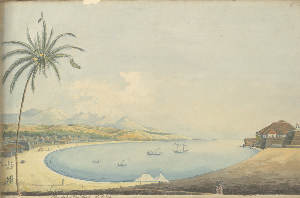
'Cannonore fort & Bay'; a watercolor by John Johnston,
c.1795-1801
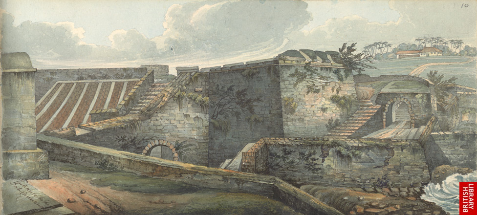
*'Entrance to the Fort, Cannanore', by Thomas Cussans,
c.1817-22
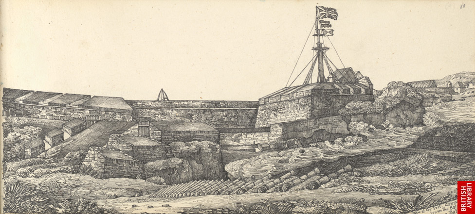
*'View of the Fort, Cannanore, from the Saluting Battery'
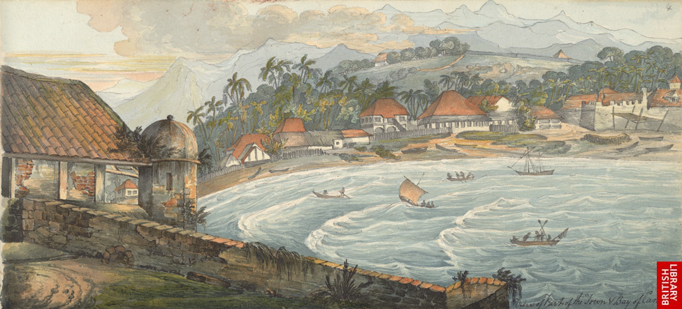
*'View of Part of the Town & Bay of Cannanore'*
A closeup of the area from Bombay to Goa, from
Stieler's Hand Atlas Uber Alle Theile Der Erde (Justus Perthes, Gotha, Germany,
1828)
A closeup of the area from Mangalore to Calicut, from a
map by SDUK, 1831 (India II
A closeup of the "Pirate Coast" area north of Goa, from a
map by SDUK, 1832 (India III)*
An engraved view of the Malabar coast based on
Daniell, 1835
Title: An Indian Splendid ceremony [India's Malabar coast, ca. 1840?]
[INDIA - SPLENDID CEREMONY - WATERCOLOUR].
Watercolour depicting an Indian splendid ceremony. Ceremonial procession with musicians playing flutes and trompettes and other musical instruments and parasols. They are followed by a group of men who are carrying the statue of the godess Shiva. The procession walks outside the walls of a temple with 3 towers.
Fête de Shiveu- Dieu consolateuo. Les fêtes des Malabars se ressemblent toutes par les cérémonies- elles consistent à promener la divinité de sortes de flûtes, de trompettes en jouent contamment jusqu'a ce qu'on ait amené le Dieu dans l'intérieur du temple, les dévots ceux qui ont fait des voeux, qui ont des faveurs des graves à solliciter y viennent casser des cocos, bruler de l'encens et du camphre, d'autres enfin y apportent de l''huile...
Description: . 48 x 30 cm. Watercolour heightened with white on paper, caption as title underneath, numbered ''5''.
Canamore fort, Race-Course, and Parade," from the Illustrated London News, 1851
*"Canamore, part of the fort, the Church, and Coorg
Hills"*
A closeup of the area around Goa, from an 1855 atlas
map by G. H. Swanston (A Fullarton, Edinburgh)*
*"The Prince of Wales
in India -- troops of the 43rd Regiment embarking at Cananore to meet the
Prince," from The Graphic, 1876
C1860 Lowry Map India Ceylon Gulf Manaar Malabar Coast
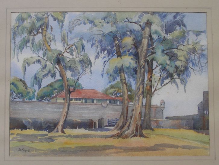
"The Pepper Pot, at the Fort, Cannanore," a watercolor by D. Kayes, 1949
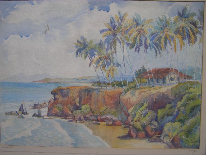
1949;"Holiday Bungalow, Cannanore"*
Join and like Face book link:
Kerala Old Photos And Heritage
Join Kannur - Cannannur Walk
Other Blog links on Calicut
A walk back to Calicut 11 Mavoor
The Kozhikode (Calicut) Beach with photos
Old Mosques in Calicut, Mishkal Masjid, Kuttichira
Calicut City Map 16th Century
Calicut -Rare photos
തളി അമ്പലത്തിന്റെ ലിങ്ക് ഇവിടെ
ചിത്രങ്ങൾ കഥ പറയുമ്പോൾChevayur Leprosy Hospital
Kozhikode Railway Station will celebrate its 125 birthday
THALI TEMPLE,A PHOTO HISTORY
Mananchira Square
Maps of Malabar Cost
Varakal Durga devi Temple
പൂർവികന്മാരുടെ അവസ്ഥ ഇങ്ങിനെയൊക്കെ ... - kalli valli
അന്ധവിശ്വാസപരമായ സ്വാധീനം-മലബാര് മാന്വല്-വില്യം ലോഗന്
Kerala old Photos part 2. 1850 മുതല് 1937 മലബാറിലെ ജീവിതവും കാലവും സ്ഥലവും എങ്ങനെയായിരുന്നുവെന്ന് കാട്ടിത്തരുന്ന ചിത്രങ്ങള് .


