Kannur St Angelo fort part 1
Cannanore Fort, a discussion over it's development . (Re posting with special arrangements from Malabar days)

Figure 1. Cananoor during the Dutch Period. [1] Please click on the image for a larger image.
The following article is an attempt to respond to a call for help from Sujith Kumar, a member of the Kannur Tourism Police who works at St Angelo Fort in Kannur. Sujith has developed a very good knowledge of the forts history and is trying to collect more detailed background to the forts history.

Figure 2. 2009 Google Earth Image of St Angelo Fort. Please click on image for larger version.
He regrets however his inability to access original sources of research material, and especially archives from the British period of the forts history. He asked if I had any knowledge of the existence of any maps or drawings from the period?
Could I help?
A number of maps and drawings survive of the fort at Kannur from the Portuguese and Dutch periods. [2]
An particular good one was drawn by Bellin and appeared in several 18th century books including J Van Schley's work of 1760. This is shown in Figure 1. above.
By comparing the 2009 Google Earth image in Figure 2 with the 1760 Dutch plan in Figure 1, it is easy to determine the extent of the Dutch and earlier Portuguese Fort, which is situated towards the end of the promontory. Apart from the later land filling into the bay on the eastern side of the fort, the area is very little changed since 1760, so where was the British Fort situated?
We know that the East India Company [EIC] spent a very large sum on the fort in the years after its final capture by Captain Wiseman, part of General Abercromby's force on 16th December 1790?[3]
Ewer wrote the following from Tellicherry.[5]
"Cannanore. Very expensive works are carrying on at this place, tis said they will cost two lacs of Rup's & that when finished they will be useless, being commanded by high ground. I am told it is proposed to level this, the expense of which would be many lac. One half of the money expended at Tellicherry wou'd make it a strong place, besides here are storehouses, & magazines, & some thousand militia can be raised in case of need.
I mention this on the authority of the first Military Character in the Country."
The first European fort at Cannanore had originally been built by the Portuguese, and was indeed one of the very first forts that they built in India. The Portuguese had intended to trade in India and were well informed about the potential locations where the trade took place in India before they had first arrived off the coast.
The first voyage had been intended for Calicut to trade with the subjects of the Zamorin. At this period Calicut was the prime trading location, but it was also very closely connected with the Arab trading system to the Gulf, and it was this same trade that the Portuguese were attempting to redirect via Lisbon. So from the first the Muslim merchants quickly realised that the Portuguese had the potential to destroy their livelihoods.
From the earliest days the Portuguese had had relationships with the Kolattri Rajah. At first this was limited to leaving goods and merchants at the settlement. However King Emmanuel of Portugal decided to send out Don Francisco de Almeyda as his first Viceroy of all the Indies. His appointment on the 25th March 1505 included instructions to built forts at Anjediva Island, Cannanore, Cochin and Quilon.
His fleet arrived at Anjediva on the 13th September 1505 and a fort was commenced straight away. Leaving a garrison on the island De Almeyda sailed south to Cannanore arriving on the 23rd of October 1505. He landed Lorenzo de Brito with one hundred and fifty men to construct the fort, and two ships to be used to guard the site and to patrol out to sea. These were not the only Portuguese at Cannanore, some two hundred had been left behind in December 1502 by Da Gama, and some of these had probably survived.

Figure 3. Showing the fort before 1572.[6]
The first fort was probably just a palisade and ditch across the promontory. This was probably soon replaced by stone. The site is built onto a rocky outcrop and the underlying rock of a very soft red ironstone like material that hardened after exposure to air.

Figure 4. Google Earth Image marked to show suggested locations
of the Portuguese walls.
Please click on image for larger version.
of the Portuguese walls.
Please click on image for larger version.
The first fort was soon under attack. The Zamorin had wide spread contacts across the Muslim World and the attacks of the Portuguese pirates and fleets in the Indian Ocean was beginning to threaten the long established trading routes from India through the Arabian Gulf and the Red Sea. Communities like Muscat, Aden, Alexandria and Damascus and even Istanbul and Venice were suffering shortages of goods.
Ambassadors had travelled to Egypt and Istanbul to request help to rid the Ocean of the Portuguese. Preparations were commenced in Egypt to prepare a fleet to sail to India to attack the Portuguese. Aware of how marginal their hold was in India the Portuguese decided to abandon the Fort at Anjediva, and to concentrate at Cannanore and Cochin.
Lorenzo Almeyda brought his fleet to Cannanore on the 16th March 1506, and was soon faced with a huge enemy fleet of about two hundred and ten ships, including ones crewed by Ottoman Turkish troops. The Portuguese had of course had experience of fighting Ottoman troops before, and this was going to be far tougher than fighting the local Indian troops. A tremendous battle at sea took place in the bay immediately south of the fort. Eventually the Portuguese cannon prevailed against the allied fleet. It retreated towards Dharmapattanam as it tried to retreat, but a strong wind got up driving back towards the north.
The Muslim fleet sent messages to the Portuguese asking to be allowed to sail north unmolested, put the Portuguese refused and attacked again causing over three thousand casualties in the Muslim fleet.
Unable to prevail by sea, the Zamorin and the local Muslim's put sufficient pressure on the new Kolattiri Raja that he deserted his former allies, the Portuguese. Da Gama's former friendly Kolattiri having died, and the Portuguese had abused the Rajah's subjects by taking their ships and possessions.
Gonzalo Vaz had captured a ship near Cannanore with passes, which he claimed to be forged, plundered the ship and then had murdered the crew who were sewn up into a sail and cast into the water. The bodies had floated ashore and included those of the son in law of Mammali Marakkar one of the most important local merchants. After confronting Lorenzo de Brito to demand recompense, receiving an unsatisfactory reponse the merchant when to the Kolattiri Rajah with many supporters, and the Rajah agreed to go to war with the Portuguese. From the 27th April 1507 the fort came under siege.
The Rajah's obtained 21 cannon from the Zamorin, and forty thousand Nairs were believed to have arrived to fight in the seige. This seems unlikely due to the size of subsequent armies, but it is clear that a substantial force was involved. The Zamorin sent twenty thousand more men to assist.
Many assaults were made, and it was at this point that it became apparent that the Portuguese had made a fundamental error when they had designed the fort. The only well was situated a" bow shot" from the wall on the enemy side of the walls. Every time the Portuguese needed to draw water they had to fight for it.
This suggests that the first wall in Figure 4 above was along the line of the defences in 1507.
Eventually an engineer called Fernandez came up with the idea of driving a tunnel through the soft rock under the wall and into the shaft of the well. They were then enabled to draw water without exposing themselves.
Most of the surviving Portuguese had been wounded at least once and food was running out. Miraculously on the 15th August 1507 shoals of crabs and prawns were swept ashore by the tide, and the garrison was able to re-supply itself.
The siege went on until 27th August 1507 a relieving fleet of eleven ships under De Cunha arrived with three hundred men from Europe and were able to drive off the besiegers.
During the siege the fort had been very exposed to fire from the higher ground to the north, and this was to be an issue for the rest of its existence as an active garrison. The attackers had used bales of cotton to raise themselves up above the height of the walls so that they could fire into the interior of the fort.
As result of the experience of this siege, and in order to enclose the well and to increase the defences it was probably decided to build a second wall in Figure 4 was built outside the first wall.
The drawing in Figure 3 was published in 1572, and it shows only one wall. However the map was probably drawn many years before the print was published.
Figure 5 below comes from a Portuguese Atlas published in 1630. It is likely however that the drawing from which the engraving was done was drawn much earlier. The text refers to events in 1567, so although the date below the fort says 1505 it refers to the founding of the fort, and not the date of the map.
As the map shows a second wall and refers to events in 1567 it suggests that the second wall pre-dates 1567.

Figure 5. Portuguese atlas, 1630.
Please click on image for larger version.
In figure 5 a town can be seen to have sprung up outside the fort itself. This town was probably under what is now the Dutch fortress. It appears to extend into the older Indian town, although there is still a substantial suburb outside the walls. This suggests that the town was segregated into several communities, Portuguese, Indo Portuguese and the Muslim subjects of the Ali Rajah.
It is interesting that the guns are shown facing out to sea. This is clearly where the greatest perceived threat was seen to lie. By the 1630's Dutch & English ships were beginning to pose a serious threat to the Portuguese settlements, and this threat is probably why these cannons have been mounted facing out to sea.
This poses an interesting question. Was the Portuguese printer re-using an older engraving and had he decided to re-engrave it to show the situation in the years leading up to 1630, when the Dutch and English shipping arriving in the Indian Ocean had become a very real threat to the Portuguese possessions?

Figure 6. Map of the fort and town of Cannanore shortly
before about 1632
during the Portuguese period, from the
Livro das Plantas de todas as fortalezas,
by António Bocarro. [Click on for larger image]

Figure 7. Google Earth Image marked up with suggested
extent of the Portuguese settlement before it's destruction by the Dutch.
[Click on image for larger version]
Working from Figure 6, and by using proportions, it is possible to mark up a modern satellite photo with an approximate line of where the two outer suburbs of the Portuguese settlement might have been situated.
Ancient property boundaries are often preserved long after the original reasons for their existence has gone.
I believe that the northern boundary of the Portuguese settlement where it met the territory controlled by the Ali Rajah or Bibi of Arrakal has been preserved down to the present day along the route taken by the Portuguese Walls. There was probably a ditch between the wall and the edge of the Arrakal settlement.
The original Portuguese fort was quite small, and would only have had a limited garrison. This would have required the fort to be built with as short a set of walls as possible. During the siege it had become apparent that these walls guarded too small and area of ground, leaving the access to the well exposed.
A second set of walls was built, enclosing the well.
As the settlement grew the population increased and required more space for housing.
Most of the new population will have been Indian's or the offspring of Indo-Portuguese marriages or concubinage. These offspring may have been regarded as insufficiently trusted to be allowed to live in the fort itself, but had to be provided with protection, so that the outer township developed within a third set of walls.
By inspection of spot heights on Google Earth it appears that the average elevation of the fort was 8 metres above sea level. The land rises up to about 15 metres above sea level to the north.
Initially this had not mattered as the potential Indian adversaries had only limited access to cannon. They were unlikely to have weapons capable of doing serious damage to the fort walls.
However, as the 16th Century wore on cannon became both more numerous and effective. The advent of Dutch and English shipping in the area opened up the possibility of attacks on the original fort from the north.
The outer wall in Figure 7 sits almost exactly at the top of the slope climbing up from the fort. By having an outer wall and suburb the Portuguese had strengthened the original fort.
For most likely scenario's against Indian forces the Medieval style walls would be sufficient against most attacks.
In the event of an insurrection amongst the Indo-Portuguese, or a successful attack on the town, the Portuguese themselves could fall back onto the fort, to await rescue by sea from one of the other settlements.

Figure 8. Portuguese Map of Cananor town.
from Plantas das Cidades de Fortalezas
da conquista da India Oriental by
João Teixeira Albernaz circa 1630
[Click on image for larger version]
[Click on image for larger version]
I have been unable to date the map of the town of Cannanore shown in Figure 8, which appears to show an earlier fort inside the town lived in by the Ali Rajah's subjects, that pre-dated the arrival of the Portuguese.
This fort might have belonged to this family, or it may have been a trading post inside the town.
It was quite common for map makers at this period to re-engrave using information from much earlier maps.
I believe that it is just possible that this map may show the situation in the period not long after the Portuguese arrived, and before they became sufficiently powerful to overawe the Muslim rulers into allowing them to extend their settlement from the fort and to build walls that run out towards the existing settlement.

Figure 9. Google Earth Image showing the same area
that is shown in Figure 8. above. The modern town
appears to have much the same street pattern as the
16th Century one.
[Click on image for larger version]
If you have access to Portuguese or Dutch material about the fort at Kannur, I would be very pleased to hear from you. It is quite possible that I have missed important points, or may have misidentified maps, ad dates of maps. If you can narrow down the dates or origins of these maps, I would be very pleased to hear from you.
It is unlikely that very much remains of the original Indo-Portuguese town that was demolished by the Dutch. This would be especially true close to the old fort, because it is known that the area was scarped and re-worked both by the Dutch and later British to clear fields of fire.
It is also very probable that the fabric of the old Portuguese walls was robbed out to provide materials for later building works. It would still be very interesting to field walk the area to the north and east of the site old town, as it is quite possible that demolition materials, debris and the remains of buildings may remain at or near the surface of the ground.
As it is quite likely to be several years before, I am able to go back to Kannur, I would be fascinated if you are able to find remains.
In my next blog I will go on to explore the Dutch period of occupation of the fort.
[2] See the following website for a particularly good collection http://www.columbia.edu/itc/mealac/pritchett/00routesdata/1700_1799/malabar/cananore
[3] Malabar Manual, by William Logan, volume 1, page 443.
[4] IOR H/438 Papers of Walter Ewer.
[5] IOR H/438 folio 147.
[6] Source: http://historic-cities.huji.ac.il/india/cannanore/maps/braun_hogenberg_I_54_3.html
(downloaded Feb. 2006)
"From Braun and Hogenberg, Civitates Orbis Terrarum I 54. Date: first Latin edition of volume I was published in 1572. After: an unidentified Portuguese manuscript."
[7] From Biblioteca Pública de Évora's photostream, see http://www.flickr.com/photos/bibliotecapublicaevora/ which contains many very interesting maps of forts in Asia during the Portuguese colonial period.
SUNDAY, 27 NOVEMBER 2016
Helen Baber, her life & final resting place

Helen Baber's grave stone, the English Church, Tellicherry.
Photo courtesy of Jissu Jacob.
Throughout much of history there have been strong wives who have supported their husbands through thick and thin. These husbands would not have been nearly as effective as they were without their wives.
It is quite clear that Thomas Hervey Baber, was extremely fortunate in his choice of wife, and that Helen Somerville Baber must have been a remarkable woman in her own right.
Like so many of these wives, however it is extremely hard to discover their complete story because she was essentially a private person in the manner of those days, and one who was hidden away from sight. She only very rarely appears in the official records, and then we only occasional catch tantalising glimpses into her life. Yet when she does enter the records, the strength of her character, and the enduring nature of her love and support for Thomas Baber comes though very clearly.
Thanks to a great deal of good luck, and a great deal of kindness on the part of Jissu Jacob a local man from Periah, Helen has suddenly been brought into view.

View of Helen Baber's table tomb, in the newly cleared church yard.
On my visit to Thalassey in 2006, I had been so overwhelmed by hospitality, that I had run out of time for adequately exploring the town. Reaching the fort as dusk fell, and only able to view over the fence into the overgrown churchyard as dusk was falling, I had feared attempting to climb into the churchyard, lest I fell down a hole, or encountered a snake.
As a result of this blog, I have been having a substantial correspondence with quite a few local people from Kerala and especially Thalassey. One of these Jissu Jacob, a local historian and tour guide was good enough to go recently to the churchyard and to take the photos in this post.
We know very little about Helen Baber's early life beyond the following passage in a note book kept by my great great great grandfather Henry Hervey Baber, Thomas Baber's elder brother.
On February 7th 1798 Henry in England, records that his father had received the following letter from his brother: -
“Feb. 7 Father hears from Tom -- Letter dated Bombay August 1797 – about the same receives a letter which came overland enclosed (by just favour) with government dispatches, requesting his consent to marry a Mrs Cameron (wife of a Major Cameron who was lately killed in an excursion down the country) she is not 18 the daughter of Mr. Fearon of Edinburgh & niece of Mr Douglas of Fitzroy Square London. She had been married to the Major about a twelvemonth.
” [1]
Thomas’s fiance, whose maiden name had been Helen Somerville Fearon, had previously been married during 1795 at the age of only 15 to Captain Donald Cameron, of the Bombay Army at Portsmouth. With the East India Company recruitment camp on the Isle of Wight nearby, this many have been a last minute affair prior to Cameron boarding an East Indiamen before setting out on the long journey east.
It had not been uncommon for girls, especially daughters of soldiers aged 15 or less to marry soldiers during this period, however it was much less common for officers to marry such young girls. Her father came from Edinburgh, and one wonders if she had perhaps run away with the Captain.
Following her marriage, she must have almost immediately boarded the East Indiaman for the voyage to India. One can only imagine what it must have been like for a teenage girl, who would still have been at school had she been born today. She would have travelled in a tiny cabin constructed towards the stern of the ship, divided from her fellow passengers by temporary timber and canvas curtains.
The ship would have been crammed full of soldiers, sailors and fellow travellers.
Conditions on-board would have often been cold, wet, and the air fetid with the smells coming up from the other decks. The relative seniority of her new husband probably meant that she ate with the ships captain and the other senior passengers in captains stern cabin. She will have been able to visit the upper deck for exercise, where no doubt she would have been an object of curiosity to the sailors.
The war with France was raging, and Britain had not yet achieved naval supremacy, so she faced not just storms and the possibility of shipwreck, but also capture by the French.
Helen will have arrived in India during 1796, probably arriving first and Surat where her husbands Battalion was stationed. Very soon after her arrival, the Battalion was mobilised to proceed to Tellicherry. Presumably Helen travelled on with the Major to Tellicherry. Given the smallness of the fort, at Tellicherry, it is quite possible she lived in tents with the Major. However, she was not to experience married life for long, for hardly had she arrived in India than she had become a widow.
Major Cameron was killed on the 18th of March 1797 whilst fighting his way down the Periah Pass. (See http://malabardays.blogspot.com/2006/12/death-of-major-cameron.html )
One can only image the pain and grief that she must have experienced at that moment, on learning that her husband was missing and was believed to have been killed.
One can only imagine how frightening, must have been her situation, she was only 17, widowed. She was in a foreign town thousands of miles from her family, and she was dependant on the charity of others.
It is not clear how Thomas first met Helen Cameron. However it is very likely that she was staying either in Tellicherry, or at Cannanore with its fort and cantonment.
As Helen had only become a widow in March 1797, and that we know that Thomas was already writing to his father via Bombay by August 1797, we can only presume that their courtship was brief and intense as are many wartime courtships.
There were very few unmarried European women living in India at this time, and those that were their were considerably out numbered by European men, so Helen Cameron must have attracted quite a lot of attention from the single officers and officials in the settlement, who would otherwise have had little opportunity of marrying, until they either went on leave after ten or more years, or chose to live with a local woman.
Aged only 20 and with only a very small salary, it must be wondered how Thomas Baber expected to be able to support his new wife. East India Company staff generally had to wait for many years and have achieved promotions before they were in a financial position to be able to marry.
Helen will have had only a very small pension entitlement from the annuity that the East India Company would have set up for her following the Majors death, and a sum from Lord Clive's fund.
This would only be payable in England, and Helen would have been expected to return to Great Britain on the first available ship.
The Major's uniform and associated belongings would have been auctioned and the proceeds handed over to his widow following his death to his fellow officers, and in other similar occurrences, it was not unknown for very high prices to be paid for items like swords at these auctions by brother officers as a way of giving support to recently widowed survivors.
Sadly we don’t know what Thomas father wrote in reply to his letter. Thomas however had not waited for his father’s permission, for as Henry wrote on 24th August 1798: -
“Father heard from Tom – when he informs us of his being married Jan 16 – 1798 to Mrs Helen Cameron – soon afterwards was appointed assistant in the revenue department at Callicut - Mrs Baber writes to my Mother.”
During December 1798 Helen was delivered of a daughter, possibly on the 1st of December, or shortly before. It has not been possible to trace this daughter beyond this brief notice, so we must presume that she died shortly afterwards, like so many other children in India in those times.[2]
Throughout the early years of their marriage Thomas was fighting the Pazhassi Rajah who was trying to oust the English from his territory. Helen must often have been left on her own, and with every chance that she would become a widow once again.
We don't know where they lived before 1809, but by then they were living in the fort.
Thomas was by then a magistrate.
Most of Thomas Baber's East India Company colleagues would have lived in houses in the fort or in bungalow's nearby. The unmarried ones would have shared houses, and probably lived a male dominated life, which probably included a fair amount of drinking and hard living.

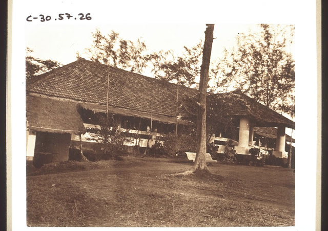
Surviving Bungalows inside Tellicherry Fort, one of which may have been the home of Helen & Thomas Baber
It is very likely that Thomas had missed out on much of this communal life, with its echos of an English boarding school common room. This was because following his arrival in Calicut in 1797 he had almost immediately been sent out into the district near Ponnani many miles down the coast to the south, in the company only of his Indian bodyguard and subordinates. Once he married he was living with his wife and was therefore living away from the other officials.
This may account for his having very different attitudes to those held by his colleagues on many issues such as slavery. These attitudes in turn may well have had the effect at setting him at odds with these same officials.
His ability to retreat to his home and to the support of his wife, probably enabled him to survive in the face of the active hostility of his fellow officials. for years.
Thomas and Helen Baber’s first son, Thomas Francis was born on the 12th of May 1802 at Tellicherry.
Writing in 1832 [3] Thomas recorded how he had first learnt of the existence of slavery in the Malabar quite by chance, when out riding one day in 1803, he had met a man by the roadside who tried to sell him two slaves.
Appalled, he bought the two slaves, a boy and a girl in order to free them. He appears to have sheltered them, and to have provided them with an education, as he recorded how one later rose to become a gentleman’s butler and the other an ayah.
Helen must presumably accepted these two children into her household, and to have played a large part in developing them. One begins to wonder if she was not just as committed a reformer as he was.
By 1808 Thomas and Helen’s eldest boy had reached the age at which he was old enough to travel back to England to commence his education. Henry, the boys uncle, recorded his arrival in England on 27 August 1808: -
“Returned to town & saw my nephew at Mrs Jones’s – this little fellow arrived in England 14th augst: he went to his grandfather augst – 29.”
Aged only six this little boy must have had some tales to tell to his uncle and grandparents when he arrived in England. He had just sailed half way around the world in the midst of a convoy at the height of the Napoleonic Wars.
The boy appears to have been sent on to school almost immediately. On 14 October 1808 his uncle Henry recorded: -
“Took my nephew to school at Mr Rowes’s Bromley – Kent.”
It must have been a terrible moment for Helen as she had to part with her boy, knowing well that they would not see each other for many years, and quite possibly never again, should either of them die.
Life must have often been very anxious for Helen, as for instance when smallpox raged through Tellicherry and the district.
Judicial from 29th February 1809. 59261.
Soon after he was established in his Cutcherry at Tellicherry the smallpox broke out and raged with considerable violence, throughout the Zillah, Mr Baber made great efforts to stop its progress by the introduction of vaccination, in which his conduct was highly approved by the Court of Directors. [4]
Thomas and Helen's attitudes towards the Indian's and slavery caused a substantial rift with his fellow English & Scottish colleagues, and I expect that a lot of the local EIC officials came to see him as both as a threat and well as a very great nuisance. After all, judged by the standards of 1809, what was wrong with having a few slaves? There were masses of slaves in the Americas, and West Indies, and the Indian’s had had slavery themselves for centuries.
Everybody knew that you went to India to make money. The previous generation of Nabob’s like Barwell, Clive and the others had been able to make many thousands of pounds. Why shouldn’t they too also have the opportunity to make a fortune?
What was all the fuss about?
One of the disputes that Thomas had entered into came to a head in 1809, and led to his eventually fighting a duel.
Thomas Lumsden Strange later recounted the story of the duel. The local officials and offices had taken such a dislike to Thomas that they recruited a army office who had a reputation for fightinf duels. This was with an officer by the name of Fortune. The two were placed back to back to measure out six paces each, when Fortune, after taking but a step or two, turned round and fired and wounded Mr Baber on the thigh, before immediately bolting. Strangely enough his second encouraged him, saying “run Billy, run!”
Billy however in his hurry to escape fell, and Mr Baber came up to him and shook his pistol in his face saying that he would be justified in blowing his brains out. [5]
Thomas survived the duel, and was morally vindicated by the mores of the time, but he was in mortal danger. Helen immediately began to nurse him back to health. She realised that it would greatly help if he could be taken up the Ghats to a higher and cooler location.
She travelled to Ponnani, and it was there that an extraordinary event occurred, which was related to me by one of the descendants of the Brahmin priest who had taken part in the events.
During 1809 the Rajah's of Travancore and Cochin had been ousted from power, by an official supported by the East India Company. This official had them begun to persecute many of the inhabitants of Cochin and the surrounding districts. The Queen Mother and Aunt of the deposed Rajah had at first tried appealing to the EIC official in Cochin to prevent these abuses, before writing to Madras to no effect.
After several months they determined to try another way of getting help. They had somehow learned that Thomas Baber was an EIC official who was sympathetic to the plight of the Indian's so they determined to send three local officials to seek him out, and to try to get his support.
The story goes that these officials found Baber at Ponnani in a house with two floors. They arrived at the house to try to meet him, but were told that they would have to wait as Thomas was too ill to come down to see them. After a few minutes Helen arrived at the head of the stairs carrying a baby in her arms, and invited them to come up the stairs to see Thomas Baber.
As the three Indians climbed the stairs, all of a sudden the baby gave a great wringle and fell from Helen's arms.
Fortunately at that moment the Brahmin was stood immediately below Helen and was able to catch the baby, preventing its tumbling to the foot of the stairs.
As the Brahmins descendant related to me in 2006, this broke the tension for them.
Eventually the truth of the situation in Travancore and Cochin came out and an expedition was mounted to remove its abusive ruler.
Helen was to go on supporting her husband for many years ahead, through both thick and thin, as I will relate in future blog posts.
[1]Henry Hervey Baber’s Memoranda relating to the life of Henry Hervey Baber.
[3]Thomas Hervey Baber “An Account of the Slaves Population in the Western Peninsula of India”, page 36.
[4]OIOC O/6/9 folio 6.
[5]OIOC Mss Eur D.358, 20th Sept 1870 Page 131 to 133.