Showing posts with label OLD IS GOLD. Show all posts

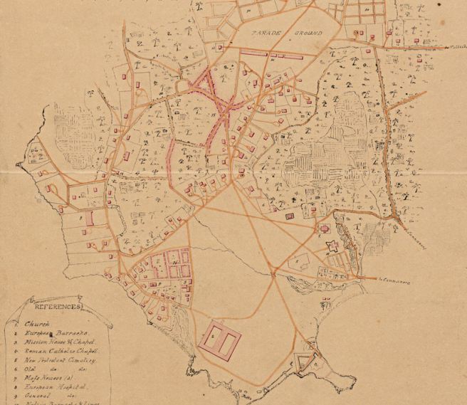
Kannur St Angelo  fort part 2

Cannanore Fort, a discussion over it's development . (Re posting with special arrangements from Malabar days)


Figure 1. The former palace of the Bibi of Arrakal. [1]


One of the most interesting of the many Indian's who Thomas Baber came into contact with, and one who he evidently had a right regard for, was the Bibi of Arrakal, known today as the Arakkal Beevis.

"The old Beebe of Cananore having written a Petition the other day she wanted me to forward to you, but which I declined, not from any wish to with hold her Petition, but that it appeared more consistent with Propriety in her writing to you herself – Whether she has done so or not I know not, but if she has you will see her case (the Subject is her Lacadive Islands) fairly stated enough and will, I think agree with me that our faith has not been preserved to her – The Court of Directors under the idea that the Islanders were adverse to her Government, were of the opinion that it was not advisable to restore the possession of the Islands to her but that to the consideration in (money?) should be allowed her on account of them – nothing however can be so erroneous as the idea of the accession of the inhabitants to the Government, and it is but reasonable to approve that they would be far better treated by her than a Farmer or even Deputy, removed at such a distance from all control, I don’t know what the advantages are the Company at present derive from these islands, but when the Beebe says (which she has repeated to me) that she will pay the Company as much as ever they received from them, and will hold herself accountable to our Government or our Courts for all her acts, there can be no objection to restoring her to her rights – She has received no compensation, not withstanding the Court of Directors orders, -- Should you view the subject in the light I do, I shall be most happy to afford my personal aid in concluding with the Beebe, (or if necessary making a survey of the Islands themselves) any arrangement that would be most acceptable to Govt for, I am convinced the Old Lady would come into any terms to regain possession of her islands." [2]

Cannanore had been an important international trading port long before the Portuguese arrived off its shores.

A Muslim dynasty based at Cannanore had controlled much of the trade from the Northern Malabar Coast to the Gulf. Following the arrival of the Portuguese who tried to control the coastal trade, this same dynasty had helped to maintain the Indian Arab trade via its Laccadive homelands, circumventing the Portuguese naval blockade by adopting routes away from the Malabar coast.

This redoubtable family was traditionally led by a matriarch called the Beebee (or Bibi) of Arrakal. Although much diminished in status by Thomas Baber's time the Beebee was obviously highly regarded by Thomas, who tried to restore her rights and previous trading business.

The extent of the former trade carried on by the Beebee and her other Muslim trading partners is demonstrated by the following answers given in evidence by Thomas Baber to the House of Lords committee on the 31st March 1830.

When discussing Mopillas... he gave the following evidence when the following questions were posed to him by the members of the committee.

Therefore they invested the Fortunes they have had in Trade?

Yes.

Do they trade much with the Coast of Arabia?

Yes.

With the Persian Gulf?

Yes; with the Red Sea, especially Judda, Aden, Mecca, and Medina, and generally with all the Ports in the Red Sea.


Are their Vessels numerous?

They were; but they are not now Half what they were, in consequence of the Monopoly of Timber by the Government, who assumed and declared the Forests to be Royalties, instead of which, those in Malabar have been purchased or inherited in the same Way as every other Description of Landed Property.

Are they unable in consequence to build Vessels?

They were for some Years. I have seen several Applications, both to the Bombay and Madras Governments, requesting Permission to fell Timber themselves, or to purchase Timber of the original Proprietors; which Requests were invariably refused, on the Ground that the Timber was required for Naval Purposes.

Has it been used for such Purposes?

Yes, it has, to a great Extent: but a certain Portion has been sold, chiefly what is called the Refuse, or Second and Third Sorts.

What Description of Wood?

Chiefly Teak and Poon.

Who were the Purchasers of the Timber which was sold, which you call the Refuse Timber?
Arabs, Parsees, and occasionally some of the Inhabitants themselves.

What is the Size of the Vessels?

The Size of the Vessels was from One hundred to Five hundred Tons. I can mention the Names of some of the Ship Owners: the Beebee or Queen of Cananore. This Lady is Queen in her own Right.

How many Vessels has she?

She had previous to the Monopoly Nine; she has now Four or Five. Chowakkara Kunhy Packey, the Heir of old Moossa, a Man well known on the Western Coast, had Twelve; that is, Moossa himself had. These are reduced, I think, to Seven. I can mention their Names and Burthen.

What was the total Number of those Vessels?

At one Time, from Twenty to Thirty of from One hundred to Five hundred Tons Burthen, belonging to the above Two Persons and other Ship Owners; besides which there were other Descriptions of Vessels, such as Botillas, Dows, Dingeys, and Patamars and Munchoos.

Those smaller Vessels carried on the Coasting Trade?

Yes; and some of the largest of them go up to Mocha, Judda and other Places in the Red Sea; also to Muscat, Bushire and Bussora, in the Persian Gulf; Porabunder, Cambay, Cutch, Sind, and a long Way up the Indus.

To what Town on the Indus did those Vessels go; did they go to Hydrabad or Sind?
Yes; I believe they go up so far at least. I have seen Bales of Cashmere Shawls brought amongst the Return Cargoes.

Are you aware whether they have ascended the River of Punjab?

No; I am not aware of any Communication with the Punjab Rivers. They go up the Indus; but I am not aware of their going there further than that. I know that Peishwoor Merchants have come down in Sind Boats.

Trade to a considerable Extent is carried on to Shiccapore, is it not?
No, I am not aware of that.

What are the Articles which are exported in those Vessels to the Red Sea?

Pepper, Cardamums, Rice, Paddy, (or Rice in the Husk,) Grain of all Descriptions, Arrow Root, Ginger, Cocoa Nuts, Kopra, (Kernel of the Cocoa Nut,) Cocoa Nut Oil, and Coir, which is made from the Fibres of the Cocoa Nut. The Value of the Produce of the Cocoa Nut Tree alone, exported from the Western Coast, is supposed to be an Hundred Lacs of Rupees.

From what Ports do those Exportations chiefly take place?
From Cochin, Chowgaut, Panany, Tanore, Perperangady, Beypoor, Calicut or Kohicote, Quilandy, (which is a favourite Arab Port,) Kotah, Barragurry, Mahe, Tellicherry, Cananore, Cavai, Bekklum, Mangalore, Cundapore, Onore, Cumpty, Seedashagur, besides numerous intermediate Ports.

Is Quilandy a good Port?

Yes; there are more of the Arabs congregate there, and more Mosques, than in any other Port on the Coast. The Mopillas here are the fairest of all the Mohamedans.

Can Vessels of 700 Tons enter every one of those Ports?

They can approach as near as a Thousand Yards of the Shore with perfect Safety, nearly all along the Coast.

Are they safe in those Ports during the Monsoons?
No; the strongest Vessel that was ever built could not ride out a Malabar Monsoon. One or Two Attempts have been made within my Observation, but they were obliged to go off.

Where do they go to when they are obliged to go off?

To Bombay; some to Cochin, where there is a very fine River.

What are the chief Importations from the Red Sea?
Coffee, Dates, and Gold Dust; Almonds, Kissmisses, (dried Grapes,) Prunes, Gums, Drugs, Perfumes, Elephants Teeth. There are several others which I cannot call to Recollection at this Moment; but chiefly, however, they bring Specie, in Venetians or Sequins and Dollars.

Do you know how far up the Red Sea those Vessels go?
The full Extent of the Red Sea. Very few of the Malabar Vessels go up that length, but they have Agents or Commercial Dealings the whole Way to Suez.

How far do the Vessels go?

To Cosheir, I think.

Have you heard of their being frequently lost?

No; very rarely indeed.

What Time do they occupy in going and returning?

They generally go before the Monsoon, and return after the Monsoon; or rather from January to April, and return from the Beginning of August to January.

From what Part of the Coast of Arabia do the Arabs chiefly come?

Chiefly from Arabia Felix.

From any principal Port?

From Aden, Judda, Mocha and Muscat, and all the Ports at the Mouth of the Red Sea.

Is much Trade carried on with Muscat?

A great deal, particularly with the Port of Cochin.

Are you aware whether any great Difficulties were experienced by the Merchants who come down the Indus?

No, I am not aware of any. Pirates were common some Years ago, but they are all destroyed, I believe, now.

The Question applies to the Navigation of the Indus itself?

No, I am not aware of any Impediment. I have often talked to the Sind Merchants whom I have met with at Tellicherry, Calicut, and Mangalore, but I have never been apprized of any particular Difficulties.

What are the Returns from Sind?

Cotton Piece Goods are all I can call to Recollection just now, except Shawls; but chiefly Specie. I think they generally purchase their Return Cargo with Money, which is so valuable to them.
[3]

It is very sad that today the ancient palace that the Bibi inhabited and which she was almost certainly visited at by Thomas Baber is now empty and decaying.  A recent article about the palaces fate can be found here..
http://www.thehindu.com/life-and-style/article3509127.ece


[1] From http://xpsajeevk.blogspot.co.uk/p/about-me.html by Sajeev
[2]Taken from a much longer letter by Thomas Baber to Sir Thomas Munro on the 25th June 1817. OIOC Private Papers IOR:MSS. F151 / 43 folio 50 – 54. to Sir Thomas Munro.
[3]From: British History Online Source: Affairs of the East India Company: Minutes of evidence: 06 April 1830. House of Lords Journal Volume 62. URL: http://www.british-history.ac.uk/report.asp?compid=16423 Date: 22/08/2004

Wayanad belongs to Karnataka

Is Wayanad belongs to Karnataka?


The geological position of Wayanad is not in line with the rest of Kerala. That is why my attention turns to this topic and a larger number of Kannada speaking communities around me in my childhood.  Even in Tribal languages in Wayanad, Kannada has more influence and resemblance than Malayalam. I think more studies and research is needed on this topic.

According to the ancient history of Wayanad, other than native Tribes, Jains are the first group who migrated to Wayanad. The Kannada speaking people in Wayanad are known as Jains, they belong to the Digambara sect and they are called Gowadas. Around the medieval period Saiva religion became a strong hold in Karnataka and the frequent attacks from Salva religion to Jain lead to the migration of Jains to Kerala and especially to Wayanad.
These names of wayanadan villages are Kannada names and it shows the influence of the Karnataka in Wayanad. All these Kannada names are the fool-proof evidence to justify the existence of Jainism this area and its influence from 12th centuary.Hoysala kings were the rulers of Kamataka'in the 12th century and Wayanad was a part of Karnataka. At that time Wayanad was known as Bailnad. The rulers of Hoysala Dynasty were Jains till Vishnuvardha. Around the medivial period Saiva religion became a strong hold in Karnataka and the frequent attacks from Salva religion to Jain lead to the migration of Jains to Kerala and especially to Wayanad.

Jainism was in its peak in Wayanad during the days of Hoysala Dynasty. Hoysala kings promoted Jainism and they sent many missionaries to the different parts to spread Jainism. There are many proofs, which justify the existence of Jainism in Wayanad. The history tells us that the Bathery Jain temple was built 800 years ago.

Earlier this temple was known as Kidangad Basti and the older name of Battery was Hennaredu Bedhi (twelve streets). These two names are Kannada names and it shows the influence of the Karnataka Jains. Some other similar place names are: Bennagode (Venniyode), Palagonthu (Palukunnu), Muthangadi (Puthangadi), and Hosengadi (Mananthavady). All these Kannada names are the fool-proof evidence to justify the existence of Jains in Wayanad.

It is believed that the wall inscriptions in Edakkal Caves (the oldest historical monument in Wayanad) are closely related to Jainism. The Swastik mark, the mark of the seventh Tirthankara, Suparswa Natha, has been engraved on the wall. The Chandrabimbamark, the mark of the eighth Tirthankara, Chandra Natha, also can be seen on the wall of the cave. The other inscriptions on the wall are the Hoysala kings'. The former Hoysalas were Jains.

In the thirteenth century, Jainism was in its peak in Wayanad. By the end of the eighteenth century the religion became too weak because of the increasing influence of the Hindu religion and the invasion of Saiva - Vaishnava religions. In this period many Jain temples were destroyed and some of them were possessed by Hindus. The relics of these ruined temples can be seen in Bathery, Puthangadi and Poothadi.

At present Wayanad is considered to be one of the important Jain centres. In Wayanad the main Jain centers are: Mananthavady, Panamaram, Anjukunnu, Varadoor, Kalpetta and Kaniyambatta

The migrated Jains first came to Panamaram on the banks of Kabani river. From there the Jain groups spread to the different parts of Wayanad. These Jains were basical1y farmers. Digging and ploughing were against their belief. So as to keep their belief they introduced eco-farming in Wayanad.  Hoysala kings promoted Jainism and they sent many missionaries to the different parts to spread Jainism.Some other similar place names with Kannada origin are given below.
 All of the place names sounds resemblance or influence of   Kannada.   I believe this the roots form is different from other names of places in plais of Kerala. But remember, Wayanad has a thriving activity of life in that era when most of the Present middle land in Kerala was covered by forest and without population.

Hennaredu Bidhi (twelve streets) Bathery.
Hosengadi ( Ondayangadi,Mananthavady).
Bennagode (Venniyode),
Palagonthu (Palukunnu),
Muthangadi (Puthangadi),
Dhottappan kulam -Dodappan Kulam,-
BAaradhoor-Varadoor,
Kolagappara Ambalavayal
Kanniya Betta, Kaniyampetta -
Kalpetta -Kalbetta ,
Hanjukonthu (Anjukunnu)
Arapatta,
Echome,
Beenachi,
Kollur,
Thaloor,Madhoor
Bavali
Muthanga -Muthangadi
Meenagadi,
Banasura, Brahmagiri. (Names of Hills)
Koottamunda
Varambatta
Bellure- Valliyoor- Valliyoorkavu( a temple of historic and social significance).

Vellamunda
Peruvaka
Ambukuthy
Nalloornad
Cherukattoor
Payyampally
Koilery
Puthiyidam
Aarattuthara
Thavinjal
Ozhakkody
Anjukunnu;
Kallumottamkunnu
Kakkanchirakunnu
Kappumkunnu
Vilakkupadamkunnu
Kacherikunnu
Panamaram
Tharuvana
Karingari
Paliyana
Kommayad
Ellumannam
Kallody (The word Kallody is derived from malayalam words kallu ( means stone ) and ody ( means run ). The combined word Kallody means running stone.Earlier this place was a forested area. The merchants from Calicut to Mananthavady town through Kuttyadi hill pass were attacked by the thieves from this area. To escape from attack, they used to carry stones with them and ran as fastly as possible. They used to pelt stones to defend from the thieves. Hence the name Kallody.
The land is divided into EDAVAKA and EDACHANA "desam". The disciple of the great Pazhassi Raja, Edachena Kunkan, belongs to this area


Balad(Valat)
Trissilery
Chundale
Edavaka
Kabanigiri
Kavumannam
Thariyode
Kidanganad
Kottebadi- Kottappadi
Kuppadi
Kuppadithara
Vaduvanchal
Muppainad
NAADBAYAL (Nadavayal)
Payyampally
Periya
Poothadi
Porunnanore
Pulpalli
Lakkidi,
Tharuvana
Thavinhal
Thirunelly
Thondernad
Trikaibetta-Thrikkaipatta
Thrissilery
Kommayad
Vellamunda
Vengappally

 AS we hear everyday these names in daily life ,we may miss the influence of Kannada in them. Try to compare these names to names of typical villages of Karnataka, or speak to a kannada speaking person.You may get some clues.


Kannur Old and Now Part 1

Kannur Old and Now Part 1

I always felt it interesting to study older days and a comparative studies with maps. I used to search in hours with Google maps, wikimapia, google earth as well as yahoo and bing maps.


A Map of Malabar collectorate. 1893


Note that the districts were CUWAY,CHERKUL,COTYAM,CARTENAD,COOROOBRENAD,WYNAD,CALICUT,
SHERNAD,ERNAD,VALLOWANAD,VETUTNAD,NEDOONGANAD.KOOTNAD,AND PLAGHAT, Pleas note the area of Calicut is so smaller and wynad is larger than in present state.


Map reading

I remember map reading was a subject in NCC when I was a cadet in school and college. Iorniclcally while I was selected as a district winner in a Shooting practice at 9th standard ,and sent for further practice camp in Cannanore cantonment,in Kannur, I was ignorant what a cantonment was.That was my first trip alone out of my house for days.
(The Cantonment was a military camp for Portuguese, Dutch and British rulers. Kannur Cantonment is the Headquarters of Defence Security Corps now.)
In that Camp we got a map reading competition. Cadets were given a hand drawn map and send them some unknown places separately by a group of 2. By reading the clues in the map we have to come in Correct place within the given time. With my companion, I came first place and got the trophy. I remember we combed the cantonment area and it was so thrilling. Other day We had shooting practice at Payyambalam Munamp. After 2 days continuous practice on that old 303 rifle.,officers may be get bored or fed up and given us packet and packets of bullets and told to shoot and empty the shells as fast as possible. They seems to require only the empty shells to the accounts.So one cadet lie in prone shooting position and aimed to the target and pulled the trigger and open the bolt, while other put shells to the rifle. We repeated & changed the position after some time and this continued. we were thrilled to hear the sound srouuh..... and aimlessly shoot parallel to ground,and to the sea and air. I remember somebody from other district put some of the bullets to his pocket and all the group was checked thoroughly and all had to remove our uniforms and even underwear and socks while in search.
I was quite deviated from the story. So I am not new to this area at least, and now I tries to compare two maps.
1. 1860 hand drawn map of Cannanore Cantonement. scale to 400 feet to 1 inch
2, 2010-2013 Google satellite map approx.from 500 meter above
They merges easily and assume that they have same measurement.Thanks for new technology.
It is a wonder that the old map(1860) was so perfect to the scale, when no modern equipment was not available. I will post the other areas as separate posts as there are lot of images to load.


Left is the google map and right is the map of 1860 of Kannur cantonment area.
As the map is so large, I have to divide as smaller it parts for easy understanding.
as a sample, here is the central piece. Able to correlate? Well ..it will be more clear when you scrolls down.
This is the Heart of the town of Kannur, Market and present police ground.  We will discuss this picture  in detail in coming posts.
  • The dotted red line is the old market place,
  • Orange lines are Mud Roads
  • The area marked in Black is a greeny means trees, marshland and shrubs. Note the coconut trees and palms.
  • No. 10 areas in rectangles around parade ground are the native barracks .
  • The Red rectangles are buildings, Mostly Of government.
  • Present Payyambalam Park and  Thavakkara were water clogged marshlands.
  • Note the rivers/nallahs as in dark lines


It is a larger view of entire area. The references are not clear in original map. But I tried to figure out almost all. The number represents an area or building.
You can compare this with the google picture of the same area In same scale.


An overview


Just imagine we are exploring the city with a map only to find the old buildings,roads and routes.
It was 1855-60,British in power in all aspects of life. Nobody was aware that once British will leave from India and we will become a nation Named India..Most local folk were living in dread full and poor conditions. Europeans are powerful government officers, and judges and was called sahibs and Madames.(Saayipp and Madhamma). They Include British,German, Ducth,Portuguese, etc.Separation and apartheid persists.European Missionaries tries to convert native peoples and got lot of finance from their countries. AS nobody knows the future, everything was controlled and maintained by them and our forefathers happily supported.Natives has no proper,dress or cloths even for ladies but considered it is natural to show the naked upper bodies in public. 95% of houses are merely Huts and roofed by coconut leaves. There was no roads in Tarmac. The Road here means mud and gravel roads for bullock carts and horse carriages. Kannur that time known as Kannan Ur and called as Cannannore by Europeans.Most of the Europeans concentrated in sea side area.
Natives where kept away but given chance for education. They respected our customs too and not destroyed the believes like Portuguese done earlier. The textile Industry flourished here and ample support and machines came by ships from Europe.


A typical street view.of Kannur.
There is a good road, with a milestone, and a street light ( possible only in a busy place.) Centre of Cannanore at that time(1860) was Kannur city.In background,see the boats and St.angelo fort..
The river or water body was clear and used for household works, means there was a dense population in nearby area.
The position of river mouth may be changed its position due to sedimentation of sand and mud and caused to form a landmass in front of old river mouth. I assume this place of photography is now near citybustand(OLD). Ayikkara road is in the picture and where this men stood in the riverbed is raised  and now using as the new open Fish Market.


Some other old photos and paintings of Kannur


A bullock Carriage Cannanore."
1896


"Cannanore1900


Payyambalam
Date: 01.01.1914


kannur probably Mappila bay
Creator: unknown
Date: 1850-.1897


In my observation,most of the goverment land and buildings were handed over to India  and enchrochment of govt land from Private owners is not much.The strong presence of Military over here is the main reason.Most of the other lands are handed over to Christian churches and estblishments.The railway andd new buildings are rapidly cailm some parts of the valuable town.
Read the next on this line about Payyambalam in my next post.

Disclaimer: This is not any kind of official study or for profit making and my intention Only for entertainment and not for any financial purposes. I do not claim the authenticity.My assumptions may get wrong.


Rare photos of Hindu Shrines around Calicut dated between 1890 to 1920

Ia's searching for some clues of old pictures  of BM photos and got too many evidences. Published them in  certain  forums and got too many enquires about the  preset situation of these places. So I Present them for your knowledge with humble note that if you know anything about the photos, please share it. You Can comment here  or in SSC  threads.തളി  അമ്പലത്തിന്റെ ലിങ്ക്  ഇവിടെ  Thali temple  be reviewd here.
 
Hindu Shrines Calicut; All photos dated between 1890 to 1920

I am going to put the new photos of same  temples and  areas with updated conditions of the place and buildings seperatly. I will publish it as a blog posts, but still I need to clarify a lot of thins anf authenticity. Some captions in these old photos are misleading and not correct, may be happened  by Western line of thinking at that time.  I think each one needs a seperate post as I did for some other structures.
 
Inner view of the main shrine, Bhagavati Temple, Elatur, Calicut taluk, Malabar district


North-east view of Mahadevasvami Temple, Beypore, Calicut
http://wikimapia.org/#lang=en&lat=11.168776&lon=75.806174&z=18&m=b&search=temple


BRadrakaali temple beypore
http://wikimapia.org/#lang=en&lat=11.167303&lon=75.803876&z=19&m=b


North-east view of Vishnu Temple, Govindapuram, Malabar District, Calicut Taluk
 

North-west view of Narayanaperumal Temple, Talakolatur, Calicut taluk, Malabar district
 

South view of Krishnamurti Shrine, Kunniparamba, Calicut taluk, Malabar district
 

South view of Krishnamurti Shrine, Kunniparamba, Calicut taluk, Malabar district


South view of the inner shrine, Mahadevasvami Temple, Beypore, Calicut taluk, Malabar district
http://wikimapia.org/#lang=en&lat=11.168776&lon=75.806174&z=18&m=b&search=temple
 

ASouth-east view of Narayanaperumal Temple, Talakolatur, Calicut taluk, Malabar district 420
 

South-east view of Narayanaperumal Temple, Talakolatur, Calicut taluk, Malabar district 421


South-east view of Siva Temple, Chevayur, Malabar District, Calicut Taluk
 

അമ്പലം, കോഴിക്കോട്,1926.
 

varakkal Temple 1901
Varakal Durga devi Temple  click her for details and comparison.
http://kallivalli.blogspot.com/2013/02/varakkal-sree-durga-deavi-temple.html


 I am going to put the new photos of same temples and areas with updated conditions of the place and buildings seperatly. I will publish it as a blog posts, but still I need to clarify a lot of thins anf authenticity. Some captions in these old photos are misleading and not correct, may be happened by Western line of thinking at that time. I think each one needs a seperate post as I did for some other structures.


Join and like Face book link:
Kerala Old Photos And Heritage
Join Kannur - Cannannur Walk

Other Blog links on Calicut

A walk back to Calicut 11 Mavoor
 The Kozhikode (Calicut) Beach with photos
Old Mosques in Calicut, Mishkal Masjid, Kuttichira
Calicut City Map 16th Century
 Calicut -Rare photos
തളി അമ്പലത്തിന്റെ ലിങ്ക് ഇവിടെ
 ചിത്രങ്ങൾ കഥ പറയുമ്പോൾChevayur Leprosy Hospital
 Kozhikode Railway Station will celebrate its 125 birthday
 THALI TEMPLE,A PHOTO HISTORY
 Mananchira Square
 Maps of Malabar Cost
 Varakal Durga devi Temple

 പൂർവികന്മാരുടെ അവസ്ഥ ഇങ്ങിനെയൊക്കെ ... - kalli valli
 അന്ധവിശ്വാസപരമായ സ്വാധീനം-മലബാര്‍ മാന്വല്‍-വില്യം ലോഗന്‍

Kerala old Photos part 2. 1850 മുതല്‍ 1937 മലബാറിലെ ജീവിതവും കാലവും സ്ഥലവും എങ്ങനെയായിരുന്നുവെന്ന് കാട്ടിത്തരുന്ന ചിത്രങ്ങള്‍ .
 

Chevayur Leprosy Hospital


Chevayur Leprosy Hospital 1904.
I worked for a short period in this hospital in 1999. I felt the same buildings has a lots of stories to tell and smelled and strong british influence there.


LETS SEE THE PICTURES,They are taken in between 1895 to 1905. A hundred years before. But the moral and standards never reach todays..


Home for lepers, Chevaym nr. Calicut 1904
 

Interior of the chapel of the home for patients suffering from leprosy in Chevaym near Calicut. The southern part 1901


Leprosy home Chevayur (Kalikut). Women's house 1903


Leper colony, Chevayur 1904 (given color)


Women lepers. Chevayur 1905


Paltman abhan Nayer suffering from leprosy, Chevaym near Calicut 1901


Lepers in Chevayur in Calicut. Dr Stokes and Miss Fritz (now Mrs Hofmann) undated


Women with leprosy in the home at Chevaym near Calicut


New home for lepers in Calicut (India). On the day of its consecration, 25th Oct. 1903


Local goverment spent 58 lack for to erect this new block in 2006!
Chevayur present state

First plan of new building in this compound
Indoor Stadium Cost: 40 crores
Location: Leprosy Hospital Compound, date of plan 2012


Join and like Face book link:
Kerala Old Photos And Heritage
Join Kannur - Cannannur Walk

Other Blog links on Calicut

A walk back to Calicut 11 Mavoor
 The Kozhikode (Calicut) Beach with photos
Old Mosques in Calicut, Mishkal Masjid, Kuttichira
Calicut City Map 16th Century
 Calicut -Rare photos
Chevayur Leprosy Hospital
 Kozhikode Railway Station will celebrate its 125 birthday
 THALI TEMPLE,A PHOTO HISTORY
 Mananchira Square
 Maps of Malabar Cost
 Varakal Durga devi Temple