Showing posts with label KANATHUR. Show all posts

Kannur- Land of Looms, A historical approach

Kannur- Land of Looms, A  historical approach

Woven  cloth


The tradition of making woven cloth dates back to Rig Vedic period. Authentic accounts about the
inhabitants of the Indus Valley Civilization used cotton for clothing as early as the 5th millennium BC – 4th millennium BC.

According to The Columbia Encyclopedia, Sixth Edition:


"Cotton has been spun, woven, and dyed since prehistoric times. It clothed the people of ancient India, Egypt, and China. Hundreds of years before the Christian era cotton textiles were woven in India with matchless skill, and their use spread to the Mediterranean countries. In the 1st cent. Arab traders brought fine Muslin and Calico to Italy and Spain. The Moors introduced the cultivation of cotton into Spain in the 9th cent. Fustians and dimities were woven there and in the 14th cent. in Venice and Milan, at first with a linen warp. Little cotton cloth was imported to England before the 15th cent., although small amounts were obtained chiefly for candlewicks. By the 17th cent. theEast India Company was bringing rare fabrics from India. Native Americans skillfully spun and wove cotton into fine garments and dyed tapestries. Cotton fabrics found in Peruvian tombs are said to belong to a pre-Inca culture. In colour and texture the ancient Peruvian and Mexican textiles resemble those found in Egyptian tombs."

South  India


Basel Mission brought about a major breakthrough in Handloom sector at the time of British rule in 1844. Basel Mission first setup the Handloom weaving factories in Mangalore in 1844 and subsequently in Cannanore and Calicut in 1852. It brought the handlooms popular in Manchester, UK and adapted to Indian conditions to run the Handloom weaving factories in the modern line. With the success of these weaving units, some of the wealthy families in the areas ventured into Handloom weaving factories, mainly focusing in the manufacture of dress materials and casements. Handloom industries suffered a setback after the Second World War and most of the factories were closed.


Title: "A difficult load with machinery on the beach in Cannanore."
Creator: unknown
Date: NA( Probably before 1890)
Please note the heavy machinery shipped from Europe and the method to embark ship to the boat and to the land of Kannur. ...It may be a historical moment. The place is not known but we believe it is in present Ayikkara beach popularly known as Mappila Bay at Kannur city, just in front of Arakkal palace. In the background, we assume, the fort of Saint Angelo.
note the costume of Men and how they enjoy.


Kannur a brief History


The Basel Mission pioneered the modernised handloom and dyeing industry in Kannur,as a centre of the handloom industry.
 The missionaries, with their hard work, maintained the quality of cloth and introduced new designs such as ‘khaki.’ Before their time, weavers had worked on pit looms (looms constructed over a pit).
The missionaries introduced the loom with a wooden frame erected on four wooden stands with a comfortable seat. A weaver could pedal the loom with feet. Also, the shuttle was thrown by the weaver beating with his hand instead of placing it through the yarns.
The innovation enhanced the production and the labourer could earn more. Though power looms were popular in Europe then, it did not exist in Malabar as there was no electricity.


Shift to factory


Title: "Transporting one of the three boilers for our weaving factory. It weighs something over 10 tons, and was pulled by 12 oxen and about 30 people. Transporting the boiler aroused a lot of interest in Cannanore. Many curious people came to see what was going on. The three boilers now stand peacefully in line in the boiler-house and will soon be making steam to drive the new machines."
Creator: unknown
Date:

The weaving centres opened by the missionaries had some sort of monopoly over their new commodity, khaki, in those days. Another contribution by the missionaries was the shifting of production from the cottage industry to the factory system. The factory system encouraged the division of labour.
 It was this transfer of technology and production system that made Kannur emerge as one of the famous handloom production centres in Malabar. Wilhem Peter Schoenthal, missionary, opened a factory with an electrically operated spinning machine made in Vorington, England in 1896. This machine helped him produce a fine woven satin cotton. This was the background of the introduction of the finest satin cotton in Kannur, which later turned to be a legacy of the textile industry here.
Local touch                                                     
The missionaries and the entrepreneurs escaped from India during the pre-World War I period and the British took over the factories. After 1947, private entrepreneurs bought them. Much before that, they spurred entrepreneurial skills in local Christian converts. One such, Sammuel Santhosh, started a factory in 1890 and his son, Aaron, started Aaron Spinning and Weaving Mills Ltd. at Pappinissery. He introduced new designing. Aaron set up the Kannur Spinning and Weaving Mills by 1944-45. When power looms were bought, the handlooms were sold to the local people.
Trade unions

The local people started their own weaving industry. This system engaged many workers in the textile industry.  Power looms later created new avenues for the industry and resulted in the emergence of an active trade union movement in Kannur. Thus, for 150 years, Kannur became a land of looms and designs.


Title: "Weaving shop and accomodation in Cannanore."
Creator: unknown
Date:


Title: "Weaving shop in Cannanore."
Creator: unknown
Date:

Title: "Weaving shop and accomodation in Cannanore."
Creator: unknown
Date:

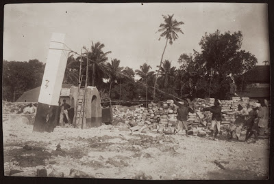
Title: "Pulling down the pillars during the demolition work, Cannanore."
Creator: unknown
Date:
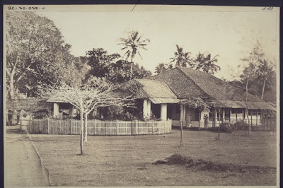
Title: "The mission house in Cannanore with its three wings - kitchen, stable, and the living accomodatioj of the missionaries."
Creator: unknown
Date:
Title: "Weaving factory office in Cannanore."
Creator: unknown
Date:

Title: "The building for spinning and reeling in the weaving factory in Cannanore."
Creator: unknown
Date
Title: "'Burnaheri' branch of the Cannanore Weaving Factory."
Creator: unknown
Date:
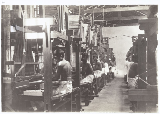
Title: "A weaving hall in Cannanore."
Creator: unknown
Date
Title: "The hall for spinning and reeling in the weaving works in Cannanore."
Creator: unknown


Title: "Cannanore: the tailors' shop."
Creator: unknown
Date:
Date:
Title: "Cannanore: building where spinning and reeling takes place."
Creator: unknown
Date:


Title: "Steam press (for hoisery materials)."
Creator: unknown
Date:


Title: "Cannanore: weaving compound. Weaving hall."
Creator: unknown
Date:


Title: "Cannanore. Compound of the weaving factory. Upstair / Dying shop / Bandy Shed / kitchen / living accomodation."
Creator: unknown
Date:


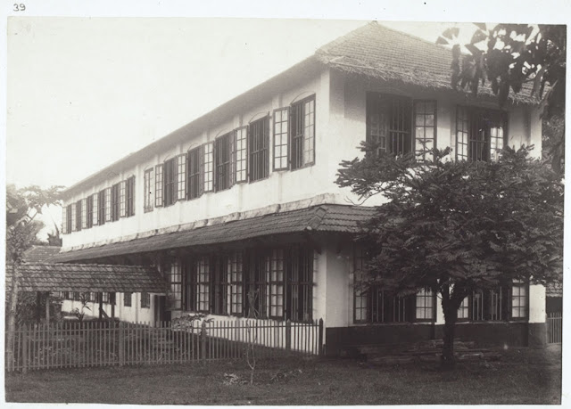
Title: "Cannanore. The new building of the weaving establishment. Seen from the front."
Creator: unknown
Date


Title: "Cannanore. Living accomodation for the weaving factory."
Creator: unknown
Date:


KANNUR or Cannannore? KANATHUR -KANNAN’S UR-

KANATHUR -KANNAN’S UR- KANNUR

Kanathur Kavu Now known as
Kanakathur Sree Kurumbakkavu


Kannur district derived its name from the location of its headquarters at Kannur town. The old name ‘Cannanore’ is the anglicised form of the Malayalam word Kannur. According to one opinion, ‘Kannur’ is a derivation from Kanathur, an ancient village, the name of which survives even today in one of the wards of Kannur Municipality.


Kadalayi Temple.

Another version is that Kannur might have assumed its name from one of the deities ofthe Hindu pantheon, a compound of two words, Kannan (Lord Krishna) and Ur (place) making it the place of Lord Krishna. In this context, it is worth mentioning that the deity of the Katalayi Sreekrishna temple was originally installed in a shrine at Katalayi Kotta in the southeastern part of the present Kannur town.


The old photo has some distinctive features:
1. There are 3 almost similar type temples in a row with the same height (usually little higher than normal) .
2.The three buildings are constructed with different materials for roof, and probably in different time of age. There may be one main God and associated with two sub-Gods,but difficult to say which one is main.
3. There is a step-like gallery at the right side and behind of the last temple(Probably a place to watch temple procession or Theyyams) associated with trees behind-(like a kavu).
4. Assuming that these pictures in the series were taken by Western photographers in that time; they took important structures inside Kannur town especially,near Fort,Payyambalam,Camp bazar and Burnassessy etc.

Kanathur Kavu Now known as

Look at the frontage and roof pattern of temple. Which is this place? What may the deity in these Temples?


The roof pattern cannot visible anywhere than Kerala, especially North Kerala and South Canara. In 1886 and earlier these are important constructions and landmark of an area, where most of the houses are merely huts.


Look at the frontage and roof pattern of temple. Which is this place? What may the deity in these Temples? So can we assume these photos are from the same location? The first one has a title, Clearly says it is from Kananthur Temple. I confused again as there is another kanathur 'Temple 'at Pallikunnu, Kannur. And looks same too.


Mr Sugunan has given an important feedback earlier:
"Empezado por sugunan Ver Mensaje
The  pic of the theyyam is from Kanathur Kavu, an ancient kavu just near to Kannur town on the way to Govt Guest House....(presently this temple is known as Kanakathur Sree Kurumba Kavu....Still ever year the same theyam is conducted in the same style from March 10-15th....
Visit the link http://www.kanakathursreekurumbakkavu.org for more details"


Somebody related to these temples and Theyyams can identify the deities and peculiarities of each one. It will make identification more accurate.


All these factors are connecting to Kanakathur Temple which appears reconstructed recently. If I am wrong, please correct me.


Quote from Sugunan: This definitely look like Kanathur kavu, and the theyyam i guess is Vishnumurthy...
Uploading a current pic of same Kavu(courtesy : Kanakathur kavu website)

Note : this is not among the 3 kavus which was shown in the previous post. This is situated in the same premises but a little away from those ones.


Kannur Old and Now Part 3 Light house,Baby beach and steep Seashore

  കണ്ണൂർ തീരത്തെ നശിപ്പിച്ച  തിരകൾ. തെളിവായത് 18 6 4 ലെ മാപ്പ് .

Light house,Baby beach and steep Seashore

Kannur old and now Part 3

Modern Satellite image and 1864 map of the same area.
The Main Road in the centre of this picture is SN park Road to Burnasseri.Government Guest house and Light house and sea view park are the highlights in this area. Kanathur kavu also can be visualised here. Most of high profile hoses and bungalows still in this area.
In a closer look, we can see little difference in the coastal boundary. Soil and hard laterite rock eroded in the course of time and hence the changes.
Light house
  The Cannanore Lighthouse near the Sea View Park is another place of interest. The first lighthouse at Kannur was built at St. Angelo Fort in, a system of hoisting a lantern with an oil wick lamp was introduced in 1843 by the British . A masonry pedestal was constructed in 1903 on the rampart of the fort and a double wick oil lamp inside the 4th order dioptric lens and lantern with arrangement for occultation was placed on this pedestal. The light was shifted in 1939 on to a 16 metre steel trestle erected on the northern bastion of the Fort. The steel trestle can still be seen today at the Fort.The light was made available during fair seasons only, from September to May every year.Over the years, the lighthouse was renovated by a flashing light with 10 second character running on DA gas in 1948 and it was moved to its current location. This light remained in operation till the new lighthouse tower was constructed at the present location during 1975-76.The lighthouse is still in use.
Photo courtesy :SSC forum Kannur

Yes. not a mistake, that half build look building was the lighthouse in 1948 in the present site. Photo on 1948.
This light remained in operation till the new lighthouse tower was constructed at the same location during 1975-76.
Modern Satellite image and 1864 map of the same area. Check-in Bing map: the erosion along the coastline is evident.


Walkway of beach: Photo courtesy :SSC forum Kannur thread
Goverment Guest house : Photo courtesy :SSC

Title:Cannanore: beautiful north beach looking south."
Creator: Klein & Peyerl, Madras, India
Date: 01.01.1921-31.12.1940
Check this photo onlooking Baby beach and farther the fort itself. you may miss the lighthouse,because it ws non exist before 1948

European Hospital
The Position of Military hospital has been recorded as European Hospital in old Map.Working from old map, and by using proportions, it is possible to mark up a modern satellite photo with European Hospital might have been situated. Same building remains in same place, wit almost same functions.
The military hospital has been recorded as European Hospital.         
Obviously, there is a separation between Europeans and Local Indians in Medical Services. A General hospital for Native public was available near old Kannur city and Church. Presently that building and area are known as District HQ hospital,Kannur. I believe this church is mostly used for the native Christians only. Europeans had separate churches at Bernassery. I will give the photos in coming posts
Here, behind Bernasseri area again we can notice the effect of erosion and land mass is reduced as compare by the old map. There were houses between the road and coastline, on Mascot hotel road.

Mascot Hotel : Photo courtesy :SSC forum Kannur thread.
Baby Beach
Baby Beach is so called because it is smaller than its larger neighbour, Payyambalam Beach. The baby beach is part of the Cannanore Cantonment and accesses restricted. 
Title :Shore in Calicut. Sea Compound Creator: unknown dated :1901
But I believe this photo was taken not from Calicut, but from the same location of Kannur.compare above photo of 1921
The lighthouse In the opposite angle, present
Compare the road and coastline in both images. Near Mascot hotel, and Baby beach the road running so close to the seashore, that underlines there is a severe attack of waves to land here. If this happens again in the next 200 years, Mascot hotel will not have a land to occupy.


But think about Mappila bay port and the problem of sand accumulation in port. May be soil from these sites slowly brought to the port. It is evident that the barrier is constructed in a non-scientific way. The sand and soil also contributes to the depth problem. We will discuss this all in the next posts.


Links of Kannur Interest: