Kannur Old and Now Part 1
I always felt it interesting to study older days and a comparative studies with maps. I used to search in hours with Google maps, wikimapia, google earth as well as yahoo and bing maps.
 |
| A Map of Malabar collectorate. 1893 |
Note that the districts were CUWAY,CHERKUL,COTYAM,CARTENAD,COOROOBRENAD,WYNAD,CALICUT,
SHERNAD,ERNAD,VALLOWANAD,VETUTNAD,NEDOONGANAD.KOOTNAD,AND PLAGHAT, Pleas note the area of Calicut is so smaller and wynad is larger than in present state.
Map reading
I remember map reading was a subject in NCC when I was a cadet in school and college. Iorniclcally while I was selected as a district winner in a Shooting practice at 9th standard ,and sent for further practice camp in Cannanore cantonment,in Kannur, I was ignorant what a cantonment was.That was my first trip alone out of my house for days.
(The Cantonment was a military camp for Portuguese, Dutch and British rulers. Kannur Cantonment is the Headquarters of Defence Security Corps now.)
 In that Camp we got a map reading competition. Cadets were given a hand drawn map and send them some unknown places separately by a group of 2. By reading the clues in the map we have to come in Correct place within the given time. With my companion, I came first place and got the trophy. I remember we combed the cantonment area and it was so thrilling. Other day We had shooting practice at Payyambalam Munamp. After 2 days continuous practice on that old 303 rifle.,officers may be get bored or fed up and given us packet and packets of bullets and told to shoot and empty the shells as fast as possible. They seems to require only the empty shells to the accounts.So one cadet lie in prone shooting position and aimed to the target and pulled the trigger and open the bolt, while other put shells to the rifle. We repeated & changed the position after some time and this continued. we were thrilled to hear the sound srouuh..... and aimlessly shoot parallel to ground,and to the sea and air. I remember somebody from other district put some of the bullets to his pocket and all the group was checked thoroughly and all had to remove our uniforms and even underwear and socks while in search.
I was quite deviated from the story. So I am not new to this area at least, and now I tries to compare two maps.
1. 1860 hand drawn map of Cannanore Cantonement. scale to 400 feet to 1 inch
2, 2010-2013 Google satellite map approx.from 500 meter above
They merges easily and assume that they have same measurement.Thanks for new technology.
It is a wonder that the old map(1860) was so perfect to the scale, when no modern equipment was not available. I will post the other areas as separate posts as there are lot of images to load.
 |
| Left is the google map and right is the map of 1860 of Kannur cantonment area. |
As the map is so large, I have to divide as smaller it parts for easy understanding.
as a sample, here is the central piece. Able to correlate? Well ..it will be more clear when you scrolls down.

This is the Heart of the town of Kannur, Market and present police ground. We will discuss this picture in detail in coming posts.
- The dotted red line is the old market place,
- Orange lines are Mud Roads
- The area marked in Black is a greeny means trees, marshland and shrubs. Note the coconut trees and palms.
- No. 10 areas in rectangles around parade ground are the native barracks .
- The Red rectangles are buildings, Mostly Of government.
- Present Payyambalam Park and Thavakkara were water clogged marshlands.
- Note the rivers/nallahs as in dark lines
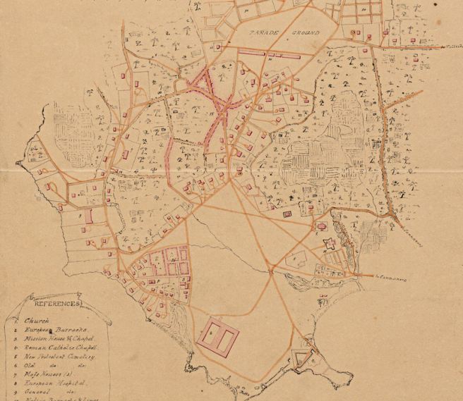 |
| It is a larger view of entire area. The references are not clear in original map. But I tried to figure out almost all. The number represents an area or building. |
You can compare this with the google picture of the same area In same scale.

An overview
Just imagine we are exploring the city with a map only to find the old buildings,roads and routes.
It was 1855-60,British in power in all aspects of life. Nobody was aware that once British will leave from India and we will become a nation Named India..Most local folk were living in dread full and poor conditions. Europeans are powerful government officers, and judges and was called sahibs and Madames.(Saayipp and Madhamma). They Include British,German, Ducth,Portuguese, etc.Separation and apartheid persists.European Missionaries tries to convert native peoples and got lot of finance from their countries. AS nobody knows the future, everything was controlled and maintained by them and our forefathers happily supported.Natives has no proper,dress or cloths even for ladies but considered it is natural to show the naked upper bodies in public. 95% of houses are merely Huts and roofed by coconut leaves. There was no roads in Tarmac. The Road here means mud and gravel roads for bullock carts and horse carriages. Kannur that time known as Kannan Ur and called as Cannannore by Europeans.Most of the Europeans concentrated in sea side area.
Natives where kept away but given chance for education. They respected our customs too and not destroyed the believes like Portuguese done earlier. The textile Industry flourished here and ample support and machines came by ships from Europe.
 |
| A typical street view.of Kannur. |
The river or water body was clear and used for household works, means there was a dense population in nearby area.
The position of river mouth may be changed its position due to sedimentation of sand and mud and caused to form a landmass in front of old river mouth. I assume this place of photography is now near citybustand(OLD). Ayikkara road is in the picture and where this men stood in the riverbed is raised and now using as the new open Fish Market.
Some other old photos and paintings of Kannur
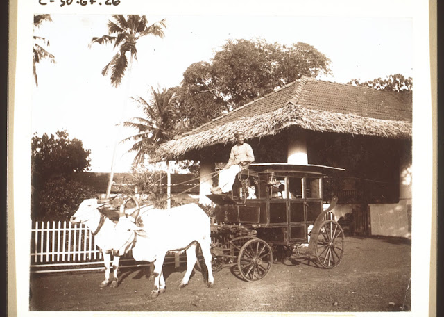 |
| A bullock Carriage Cannanore." 1896 |
 | ||||
"Cannanore1900  
In my observation,most of the goverment land and buildings were handed over to India and enchrochment of govt land from Private owners is not much.The strong presence of Military over here is the main reason.Most of the other lands are handed over to Christian churches and estblishments.The railway andd new buildings are rapidly cailm some parts of the valuable town.
Read the next on this line about Payyambalam in my next post.
Disclaimer: This is not any kind of official study or for profit making and my intention Only for entertainment and not for any financial purposes. I do not claim the authenticity.My assumptions may get wrong.
|


hello please let me know your email id
ReplyDeleteDisclaimer: This is not any kind of official study or for profit making and my intention Only for entertainment and not for any financial purposes. I do not claim the authenticity.My assumptions may get wrong. Please correct in such cases by sending a mail to jeevan.guru@gmail.com
DeleteVery Nice blog post. Declared as one of the ten best places to stay in India, Cannanore or Kannur poses a strong colonial heritage. Click here to know about various places to visit in Kannur.
ReplyDeleteNice pictures and post on history of Kannur . Kannur is known as the land of Looms and Lore. Along with beaches and forts there are many places to visit in Kannur which attracts travelers.Thanks for sharing your post.
ReplyDeleteHi... I am a post Graduate Urban Design student and interested in knowing more about Kannur Cantonment area as I belong to Kannur. Is there any way you can share a quality image of the old map showing the cantonment area? Please respond.
ReplyDelete