I feel it interesting to study older days and comparative studies with maps. I used to search in hours with Google maps wimp google earth as well as Yahoo and Bing maps.
I remember map reading was a subject in NCC when I was a cadet in school and college. Ironically while I was selected as a district winner in a Shooting practice at 9th standard, and sent for further practice camp in Cannanore cantonment, in Kannur, I was ignorant what a cantonment was. That was my first trip alone out of my house for days.
In that Camp, we got a map reading competition. Cadets were given a hand-drawn map and send them some unknown places separated by a group of 2. By reading the clues in the map we have to come in the Correct place within the given time. With my companion, I came first place and got the trophy. I remember we combed the cantonment area and it was so thrilling. Oher day We had shooting practice at Payyambalam Munamp. After 2 days continuous practice on that old 303 rifles., officers may be getting bored or fed up and given us packet and packets of bullets and told to shoot and empty the shells as fast as possible. They seem to require only the empty shells to the accounts. So one cadet lies in prone shooting position and aimed to the target and pulled the trigger and open the bolt, while other put shells to the rifle. We repeated & changed the postilion after some time and this continued. we were thrilled to hear the sound srouuh..... and aimlessly shoot parallel to the ground, and to the sea and air. I remember somebody from other district put some of the bullets to his pocket and all the group was checked thoroughly and all had to remove our uniforms and even underwear and socks while in search.
I quite deviated from the story. So I am not new to this area at least, and now i tries to compare two maps
1. 1860 hand-drawn map of Cannanore Cantonment. scale to 400 feet to 1 inch
2, 2010-2013 Google satellite map approx.from 500 meters above
They merge easily and assume that they have the same measurement. Thanks for the new technology.
It is a wonder that the old map(1860) was so perfect to the scale when no modern equipment was not available.
Disclaimer. This is not any kind of official study or for profit and my intention Only for entertainment and not for any financial purposes. My assumptions may get wrong.
 |
| A MAP of MAlabar collectorate. 1893 |
Note that the districts were CUWAY,CHERKUL,COTYAM,CARTENAD,COOROOBRENAD,WYNAD,CALICUT,
SHERNAD,ERNAD,VALLOWANAD,VETUTNAD,NEDOONGANAD.KOOTNAD,AND PLAGHAT. Please note the area of Calicut is so smaller and wynad is larger than in the present state.
 |
| Left is the google map and right is the map of 1860 of Kannur contonement area. |
As the map is so large, I have to divide as smaller it parts for easy understanding.
as a sample, here is the central piece. Able to correlate? Well ..it will be more clear when you scroll down.

Heart of the town of Kannur, Market and present police ground. The dotted red line is the old market place, Orange lines are Mud Roads, the area marked in Black is a greeny means tree, marsh land and shrubs. Note the coconut trees and palms.
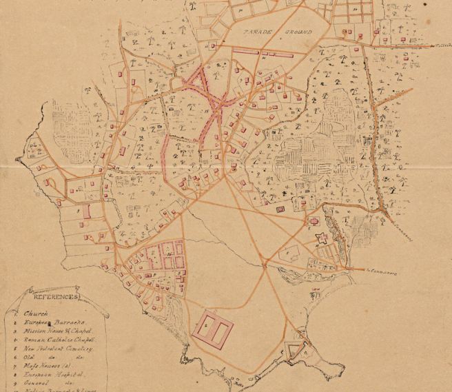 |
| It is a larger view of the entire area. The references are not clear in the original map. But I tried to figure out almost all. The number represents an area or building. |
You can compare this with the google picture of the same area On the same scale.

An overview
Just imagine we are exploring the city with a map. Just to find there old days and routes
it was 1855-60, British in power in all aspects of life. Nobody was aware that once the British will leave from India and we will become a nation Named India. Most local folks were living in dreadful and poor conditions. Europeans are powerful government officers, and judges and was called sahibs and Madames. (Saayipp and Madhamma). They Include British, German, Dutch, Portuguese, etc. Separation and apartheid persist. European Missionaries tries to convert native peoples and got a lot of finance from their countries. AS nobody knows the future, everything was controlled and maintained by them and our forefathers happily supported. Natives have no proper, dress or clothes even for ladies but considered it is natural to show the naked upper bodies in public. 95% of houses are merely Huts and roofed by coconut leaves. There were no roads in Tarmac. The Road here means mud and gravel roads for bullock carts and horse carriages. Kannur that time known as Kannan Ur and called as Cannannore by Europeans. Most of the Europeans concentrated in the seaside area.
Natives were kept away but given the chance for education. They respected our customs too and not destroyed the beliefs like Portuguese done earlier. The textile Industry flourished here and ample support and machines came by ships from Europe.
Let us start by a round trip over Kannur
Let us start by a round trip over Kannur
Start with Payyambalam, you can note the space for Payyambalam Park, bay Heights sreerosh properties, and a number of high rises,Payyambalm munamb,Ursuline HS School,Church and GVHSS for girls.


Lighthouse
Main Road in the centre of this picture is SN park Road to Burnasseri. Government Guest house and Lighthouse and sea view park are the highlights. Kananthur kavu site also can be visualised here. Most of high profile hoses and bungalows still in this area.
Main Road in the centre of this picture is SN park Road to Burnasseri. Government Guest house and Lighthouse and sea view park are the highlights. Kananthur kavu site also can be visualised here. Most of high profile hoses and bungalows still in this area.


Burnassery /Benarsherri.
DSC pay office lies in the centre of the triangle followed by proper Burnassery. In 1860 map please note the number 16. It corresponds to a marked area in red and captioned as Bunacheri. This area had some important mission buildings but now holds modern private houses and shops. No 3 in the old map was he place Mission houses and accommodation. Check for the mission buildings photo down. No. 4 was a Catholic church now still exists in a modern building called Holly Trinity church. Note the site of St Teressa's Anglo Indian Girls HS /BEMP girls school. Mascot Hotel is another important landmark here.


Cantonment
As the Road ends here to the restricted area of the cantonment, we a notice the same area is being used as the same purpose. Military Barracks and offices. It was English/European Barracks and Indian soldiers of Britain were kept at a distance in so-called Native barracks at a 2 km away after the Parade grounds.


Kannur fort (St Angelo's Fort )follows. The fort road continues up to the fort and still under the custody of Army.other inner roads are not opened for public.
Mappila bay is enacted but shape changed greatly. Now it has two breakwater barriers and part of it used as a fishing Harbour known as Ayikkara.
Fort is still in its glorious state and well maintained by Archaeological Department. Some office of Archaeological Dept functions inside the fort and it is a popular picnic, touristic and film making the location. The outer canal marked its boundary correctly. Importantly, a triangular shaped outer fence was there as a strategic defence system near the parking area what visitors almost go unnoticed. We can assume that the bridge connecting to the fort from the parking area is relatively new. There was another small bridge in this photo. The present bridge was destroyed as you can clearly see in the old photo. Please check down for new photos for a comparison..The second inner canal also kept well preserved till now.


Dt Hospital and the English Church
We further move from Mappila bay to Kannur City and District hospital area. The old map says there were important landmarks of European Hospital ( 8)(now District Hospital), a church(1) and artillery camps (11)now DSC Engineering Wing near to the DH Bus stand. The open place below DSC park was so open in older days and you can notice in the photos below. now it holds numerous fishermen Huts instead of one hut in the place. have you noticed a group of coconut trees and a hut below that in the seashore? surprisingly it was depicted in the map too and look for a comparison in other photos. it means the map and photo correlate with that time.


We may go back to the district hospital road to fort road and Railway station road. No .6 was the old cemetery for protestants. Still it's there intact. There was an important place that I cloud not clearly figure out int the place of old Prabath Talkies. But in the backside of Prabath, the huge marshland starts and occasionally there were Europeans houses along the fort road. Note the Fort road circle. At the junction and Ballard Road crosses all the roads in an obtuse angle only to end it to the church. So My assumption is Ballard Road was a very important road which connected Parade ground to Market to the Church. Part of that important road is not in use as our army and Railway station establishments clearly put an end. Onden Road also directly opens to this road and goes to Church.
Note the site of St Micheal's Anglo Indian Boys School. Note that new Thavakkara junction near SBI was important meeting points of that Mud filled roads and Netaji road has existed then. The plot of SBI had a government building. Old Post office is replaced by SBI.


Market place
Now come on the real market place of the city. As you can see the dotted red line in the old map, it denotes an important market place. The no.15 denotes camp Bazar. the X and A figures in red dotted line still exist today as a busy market. MA Road and Hajee road marks the X.Ballard road straightly goes to the Railway station, and there was no railway at that time it directly goes to the parade ground along with fort road and SN park Road. JS Paul Corner is also important Rajiv Gandi Road was Non exist which connects to Moideen Palli. You can see a new road called Station Road. As the name suggests it run parallel to the railway track and station from Thavakkara.It lies at 90 degrees to all major roads of the old town and terminating them abruptly. This is the reason why it has the highest traffic block in these years.


.Now come to the new area of Thavakkara. There was no railway line through this area. And hence no thavakkara underpass. It was a Marshland with few trees and shrub forest. Till recently it claims at least a part of it but New Bustand and Kannur university buildings destroyed it almost completely.

 Do you wonder where is the new building od University is? it was 2010 image and look below for new image 2013 of the same area and find the differences.
The Railway Station
As there was no railway it is not shown in the old map. The site of Railway divides the Kannur town and separate some important road by cutting a portion of them. They are SN park Road, Ballard Road and Fort Road. SN park Road was cut by an end which was gone directly through the overbridge from Muneeswaran kovil Jn to press club road to join the stadium Road. It is true that the present underpass road of old bustand existed then as a small road. Ballard road continued directly to the Railway station front area and passes through the station to join stadium road through AR camp. Fort Road also bisected by Railway station near the railway dispensary, and second parking area for cars, start point of the First platform joins the road of KTDC Yatrinias and then to collectorate road. AR camp area and police quarters was barracks of Native Soldiers of British Army.you can see as No 10 in the map.


The Parade ground
The Parade ground in original was slightly large and surrounded by Native barracks of soldiers. It included present-day Stadium, Police parade ground, Police Maithanam, Traffic police Station, Collectorate, Town square, PWD offices and other government offices till Caltex Junction.
Head Post office stays in the same site as the old Post office.
The square figures are where present buildings stand like District veterinary centre, Cessions court complex, Municipal office, Townhall, police quarters, Jawahar library and Chinmaya Vidyalaya once was again barracks of Indian Soldiers.No10
The Central road which divides the old parade ground on the old map not exists now. Instead, there is another separate small road between the stadium and police gound.
The area around KVR tower and Mahatma Mandiram, Fatima Hospital was a site of an important govt establishment, but I could not figure out what it was. It is not the GHSS. something else.


AKG Hospital, Caltex, and town hall Triangle.
There were roads to the North. Thaliparamba Road from Traffic SPCA junction and NH 17 Joins toat AKG Hospital Junction. All these areas were barren land with occasional trees and shrub forests. the


Caltex Junction
Caltex Junction Is the most buzzing centre of present Kannur. The Trijunction in the upper side of Map still exists the same size and length in the NH 17. It called South bazar or Thekki Bazar and the other road to the right is Kannothumchal road. The area between Thekkibazar fish market and fuel pump in Caltex junction and it beyond till BSNL office makes a square area and it also hosted Native(Indian) Barracks of the British army. The triangle area in between Taluk office,sub-jail Indian Coffe house DTPC and Ghandivanam had some supplementary tents and denoted to the army.
New Caltex Junction is modified and formed slightly taken some lands from present KSRTC Bus stand and surroundings. The Curve Of NH is somewhat new. and the old road till collectorate says its width and glory.


Thayatheru Road and Marshland
From Caltex junction along Tellicherry side and within 100 metres this important road begins and known as Thayatheru Road. It was the in the old map a joined the original main old road Ballards road at Chirakkamkulam. Thaytheru Road marked the boundary of marsh land at that time. Now there is an underground railway Cutting at Chirakkamkulam and seems it is not good for this old and important road. In fact, Railway bisects all major road in the town and made some difficulties to the growth of the areas when speaking in the long term perspective.


Thankyou so much for the information.... It will be great if you could share when exactly the development of the kannur stadium , parade ground and the regions around it took place? (years, reasons etc) The reasons for the growth of the town in that particular direction (cultural ,geographical, socio political reasons etc ...)
ReplyDeleteThank you Meeradevi, but what you asked has a vast reasearch and scope for a research paper. I do not have such a knowledge!
ReplyDeleteMore detail's about araakkal kettu and old city
DeleteThis comment has been removed by the author.
DeleteThank you so much .... Whatever you have displayed has helped us a lot... Keep going... :) If you do get any information about Kannur administrative town please do share it with us...
ReplyDeleteIts wonderful attempt.
ReplyDelete3456
ReplyDeleteIncredible work! Thank you.
ReplyDelete