Maneater of Crescent Mountains-A guide for a walk back
This time I am talking about a
different location of KA tracking. Its Baba Budans or Mountains of
the Crescent which is located in Chickkamagalur district in Karnataka where the story
The Man- Eater of the crescent Mountains has taken place.
Before we start, let me remind you that I
didn’t go there, but planning to go in the near future to this beautiful piece of
land. If you start from Bangalore, The nearest town is Birur / ಬೀರೂರ in Chickkamagalur
district and is just seven kilometers from Kadur which is taluka headquarters
.This town is also a center for areca nut trade and business and is well
connected by railway and state highways.
 |
The Man-Eater of the crescent Mountains is the story of a tiger that lived in the Baba-Budan Range or Chandra Drona Parvatha. |
 |
| The location of the story Man-eater of Crescent Mountains |
If you look at Google earth the range looks similar to the crescent moon. Anderson has
provided a sketch map of the locality where the man-eater of the Crescent Mountains
operated.
At the beginning of the story, Kenneth Anderson has described the topography of the
Baba Bundans or mountains of the crescent. He describes vividly evergreen forest
known as the Jagar valley, which is now called Bhadra National park. KA mentions that this valley is the home of bison and sambar in vast numbers, also
the heavy rainfall that makes the valley dense and dark region. He describes the
density of the thick jungle by referring to various insects that inhabit there.
Then he describes the location and routine life in the village known as
Hogarehalli.
 |
| Marked in Blue, the range looks similar to a crescent moon. Hogera Halli Madakk lake and Birur are marked. |
Anderson mentions the arrival
of the tiger in a dramatic manner. He seems appeared out from the Jagar valley but few people said that
the tiger wandered in from quite a different region, very far away, known as
Lakkavalli and the Lalbaugh, because of the disturbance in the jungle as a
result of the construction of a large dam across the Bhadra River. If you read KA a lot, the names of the places in this locality may be familiar to you. Arsikere, Yemmadoddi, Ionkere,
Sakraypatna(Alum Bux),Ganjur, Lingadahalli, Bellundur, Amligola ( I think it is Umblebylu),
Holalkere, Tarikere, etc are being placed in short distances on this vast area as far as I know.
So if we make a trip, we can cover the following stories and places
altogether in two or three days.
The Man eater of Yemmadoddi , The
Bellundur Ogre ,The Aristocrat of Amligola, The Lakkavalli Man-eater , Alam Bux
and the Big Black Bear ,The Man eater of the Crescent Mountains and The Hosadurga- Holalkere Man-eater are the stories which can be explored altogether. Kumsi, Narsipura, Jog falls, also can be
added on an extension of the trip for The Maned Tiger of Chordi.
 |
| Baba-Budan Range which has one of the highest mountain peaks between the Himalayas and the Nilgiris |
 |
| A handout picture of Jagar valley, taken by Kenneth Anderson with an inscription of of "an infra-red view of the Jagar valley" with his own handwriting: Photo credit to Mr. Joashua Mathew, with special arrangements. |
Baba-Budan
To the north of Chikmagalur town is
the Baba-Budan Range or Chandra Drona Parvatha as it was known in olden times,
which has one of the highest mountain peaks between the Himalayas and the
Nilgiris. The loftiest point of the range is Mullaiyanagiri which is 1,926
meters above sea level. The three large caves here said to have been sanctified
by 3 siddhas contain their icons and ‘gaddiges’ (tombs) and an annual jatra is
held here in their honor. The enthralling scenery around makes this a much-frequented pilgrim center. Seethala Mallappana Kanive to the left side is said
to have been hallowed by Sidha Seethalaya and contains a Matha and the dual
shrine temple of Seethala-Mallikarjuna. The Baba-Budan range has taken its name
from the 1895 meters high Baba-Budan Giri, situated just 28 kms north of
Chikmagalur town. A beacon lighted here during Deepavali can be seen at
Chikmagalur. The peak takes its name from the Muslim saint, Baba-Budan, who
took up residence here for more than 150 years ago and brought the coffee seeds
for the first time from Yemen.
 |
Baba Budangiri Range is a range takes its current name from
the Dattapeeta Cave and 17th century Sufi saint Baba Budan. Unique mountain
flowers called kurinji blooms in these hill ranges once every 12 years.
|
Man eater of Crescent Mountain ... look The story
Click images for zooming.
 |
| The first page of the story, Hogarehalli, and nearby hill Hogarkhan is marked, with relation to Birur |
The essence of the story:
The Maneater arrived suddenly and
started killing human beings, near to his camp at Hogarehalli and the nearby hill
Hogarkhan .Anderson gives a detailed account of such attacks on the villagers in
the area. The tiger returned from the Jagar valley after disappearing for a few
months and started his campaign of murder on the slopes of the hill. The tiger
created its terror in that region when Anderson with his son, Donald and a
German friend came there. They reached there to collect a few baby crocodiles
and other reptiles for their German friend. Anderson here provides information
about the crocodiles in the Cauvery River. He describes how crocodiles were
hunted by the hunters employing ingenious methods. After failing attempts of
catching baby crocodiles on the shores of Ionkere, he returned to Bangalore. Later
the village Patel posted a letter to. Anderson and his son so decided to rid
the man-eater of the Crescent Mountains.
In this story, Anderson narrates why he procured so many pieces of lands
for his camping sites. Anderson has
given very vivid account of their operation and at last, succeeded in killing the
man-eater of their successful hunt. An unfortunate Leper had been prey for the
man-eater and saving their own life while they were asleep over the bund of
Maddak Lake. After one day's entire wait in a nulla bed, Donald was able to
shoot the tiger lake when he returned to the kill. He narrates how the proud
Patel and the grateful villagers forced him and Donald to stay at Hogarehalli
for the night feast to celebrate after the death of the man-eater.
 |
| Hogerkhan is situated to the east of Crescent mountains, marked in BLUE. |
 |
| 3D map of Bababudan Giri (BLACK ARROW) , relative positions of HOGERKHAN (BLUE ARROW) and Maddak lake (RED CIRCLE) |
 |
| 3D map of Maddak lake (BLACK ARROW) , HOGERKHAN (BLUE ARROW) Hogerahalli (GREEN ARROW)and Birur (RED CIRCLE) |
 |
| The names of the places mentioned in the story are little deviant to the present names. We know Anderson sometimes misspelled the names. |
I used the same names as KA said, but these names are equivalent in the present :
Hogar Khan= Hogarekaan= Hagarikan=
Hogerekangiri
Hogerahalli= Hajerahalli
Jagar valley= Bhadra national Park
in (Mysore gazetteer used as Jagar
Valley)
Maddak lake= Maddock lake=Madagadakere
Ion kare = Ayyaanakere,Ayyankare.
Yemmaydoddi= Yemmedoddi
 |
| View from Hogerekangiri |
 |
| Hogerahalli and two footpaths arising from it. The first one(Red line) leading to the hills of Hogerkhan hills. The other one past the tank(in the small white square) for about 3.5 kilometers (yellow line) to a canal (yemmedoddi channel- green) |
 |
| The very lofty temple, Built from the red sandstone from the area. Now glittering in golden paints. Ranganatha temple. |
 |
| Yemmadoddi Canal which is originating from Madagada Lake is marked. It is a very ancient man-made lake. |
 |
| Near to Chickmagalur, Its a quite vast area, where the man-eater has operated. |
 |
| Probably the man-eater came from these two places. Regular readers of KA can remember the places in other stories. |
 |
| Comparison of Google and KA hand-drawn maps. click the image for zoom. All points are matched exactly. |
Our
present area in this story also described in another story very detailed and wonderfully, so
looks at the topography from that story: The Man eater of Yemmadoddi
Yemmadoddi is an area of bordered
by a ridge of foothills, the highest of which is named Hogar Khan, that form
the eastern spurs of the great mountain range known as the Baba Budans, A a magnificent lake, called the 'Madak', entirely surrounded by forest-clad hills,
forms the southern limit of this area, from which a narrow water-channel,
paralleled by an equally narrow forest road, runs for ten miles north-east-
wards, till the former, joins a smaller lake about three miles north of the
little town of Birur. This area is rich in game, and still richer in vast herds
of cattle that are driven into the forest by day to graze, and driven back each
evening to Birur Actually, Leopards are fewer in number than their bigger
cousins, and confine themselves to the outskirts of the town itself, well out
of the tiger area, because of their fear of the larger animal to whom they
themselves sometimes fall prey.
 |
| The path from Hogerahally towards Yemmadoddi Channel. Orange Garden is also noted. Please note the waterbody here is not seen on the old map. On my search, I got the info that this was an abandoned lake known as Hale Madagada Kere. This old Madagada lake, hundreds of years old, restored recently about 25 years back. |
 |
| 3D picture of Hogarekan and showing its slopes and shola forest. It has unique biodiversity, combined with various Mutts and shrines along the slopes. Now Mining at Hogarekan hillock will pose a danger to Siddeshwara cave temple, on locals opinions Hogarekan is the land of seers and sages. |
 |
| Possible estates area and the watercourse. |
 |
| The rainwater collecting tank near Hogerahalli is marked in the red circle, where the boy has been picked by Maneater of Crescent mountains. Google earth shows a trail to the maddak lake(BLUE), where the Lambani poacher became prey to the tiger. |
 |
| Closer view of the tank and hogerahalli, as described the oldmap. The probable site Camp(My land) is also marked. Anderson nearly pinpointed his own land, I think here only. |


The above pictures are taken from Google Earth where Kenneth Anderson procured a land. Fist image in 2006 and second picture in 2014. You can see hardly any developments in this little village.
 |
| A handout picture of Hogerahalli, taken by Kenneth Anderson with an inscription of "Looking east across our land. " on his own handwriting: Photo credit to Mr. Joashua Mathew, with special arrangements. That means he should have to look in a straight line towards Birur. This will be a good clue for locating his land for explorers. The location can be seen on google earth. 13°34'28.03" N 75°53'31.63" E |
 |
| The pathway where the Lingayath boy carried off while descending the hill on his way to Birur from Hogarkhan hill |
 |
| Positions of Maddak lake and Ionkare separated by six miles. (Madagadakare and Ayyanakere) sometimes Ayyanakare is referred to as Big Madagada Kere . With mining activities, recently the underground water in the surrounding region, including Ayyanakere, Madagada Kere which was supplying water to most of the villages in Kadur, would soon deplete and a large amount of silt would be filled in them. |
 |
| Ayyanakere. This place is also described in Alum bux story. |
 |
| Iokere was famous on Crocodiles at that time...The low-level Mud and sand areas where crocodile once thrived can be seen. |
 |
| Ionkare, cattle Patti and Maddak lake. Anderson and Don walked cross country for six miles tin search of man-eater in dark |
 |
Madagada Kere or Madak Lake. One of the finest old tanks situated Yemmadoddi forest, and feeds to 9 Balancing small tanks, irrigates more than 5000 acres of land. courtesy :Prashanth
|
 |
The tank is quite an ancient one (700 or so years old) but has come under rejuvenation during various periods, dating to the Hoysala period and as recently as 25 years by the minor irrigation department. I do not know if the dolmen is typically from the megalithic/neolithic period, given the large scale construction work that would have taken place to reinforce the bund. There is no display board to suggest since this is a historical site. courtesy: Prashanth
|
 |
A typical hero stone. It is also possible that this was from a place in the immediate surroundings and may
have been placed on the bund as in the case of many hero stones. courtesy: Prashanth
|
 |
Madagada Kere bund. Hills of
Hogerkan (Hagarikan) giri; in the direction of Birur from the tank bund
|
 |
| Madagada Kere That is the vast expanse of the magnificent lake. Mullaiyanagiri and Bababudan Giri in the background (faint silhouette) Anderson describes small Signe and big Signe in his story, probably about the hills. |
 |
| A handout of two pictures of Maddock lake(Madagadekere, Maddak lake), taken by Kenneth Anderson with an inscription of "Muddock Lake and the Signies. " on his own handwriting: Photo credit to Mr. Joashua Mathew, with special arrangements.Must be from at a location of his camp at different timings of the day. The word meaning of "Signies" can be applied here to hills. Can you assume the name of the hills seen on the background? To answer it Google earth is our main tool. It is not the Crescent mountains as the silhouette of the crescent mountains in the above photo is not similar to these hills. |
 |
| 3D view of Madagadakere lake when looking towards Hogerahalli and the towering hill must be Hogerkhan itself! |
 |
| Zoomed view. There is not much distance to the far end of the lake, and a very flat bank with some sort of trees or thick vegetation at other ends of the lake. So the lake bund must be situated at the left side of the photo. |
 |
| Anybody can identify this person? |
 |
| The mango grove and some devotions to the lord. This is the probable site where the unfortunate Leper seeks asylum for that night. There is a zinc Hut nearby, now converted to a concrete one, but I could not procure a photo. |
 |
| Cubbon Park police station. The Cubbon Park Police Station is perhaps the only one of few extant heritage buildings among police stations in Bangalore. KA describes he visited this station which is nearest to his house, to seek the help of a policeman to read a letter from Mudaliargiriappa. The letter was in Kannada which informing a man-eater is operating in Hogerahalli area and summons Anderson's immediate intervention. |
 |
| Main temple compound. As per some indications, The Patel"s house was on right side of the temple. |
 |
Hogerahalli and probable place of Patel Mudaliagiriappas house. It is near to the Main temple of the village. there are 3 temples in Village.
|
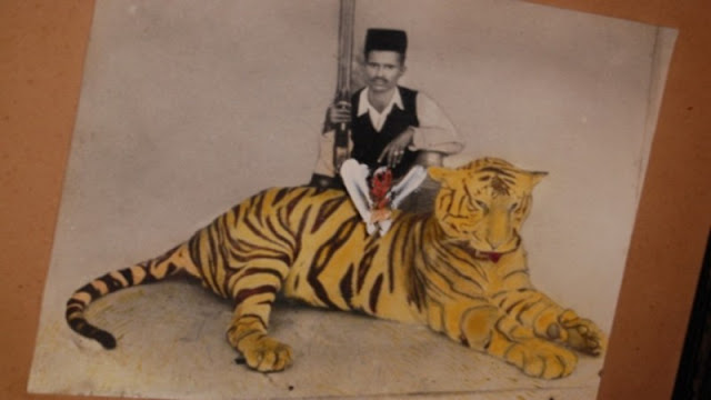 |
| Edited hand printout of former Patel and hunter,Mudaliargiriappa on his prime age. Mudalagiriyappa, was a friend of Anderson. The photo must be taken before KA met him because KA described the man is an old man and who served KA and Don with Buckets of curry and rice followed by vast quantity heavy milk tea. Photo courtesy to Mr. Karthik, who procured the pic from former petal's relative on his visit to the village. |
 |
| He is the relative of old Patel. His name is also Mudalaliargiriappa. Upon questions by Karthik, he slowly began recollecting him, considering he was only a small boy then. More importantly, he remembered a companion of Anderson with ‘wooden leg’ Mr. Jonklaas, the Dutchman who finds frequent mention in Anderson’s books. Karthik also met the widowed second wife of former Patel-hunter Mudalagiriyappa. As she was married to the man at a young age, she narrated how she used to welcome Anderson and force him to down rice and curry, with Anderson himself reciprocating the hospitality by offering canned meat and how her husband died early, all vaguely described. |
 |
3D reversed view of Hogerahalli using google earth. Hogerahalli and campsite, with hogarkhan hills on background. position of Yemmadiddi and MAddak Lake can be assumed in this view. The dotted line represents a possible forest boundary at that time, the story took place back in 1948.
|
 |
| Birur- Lingadahally road with the bridge where KA and Don parked their Plymouth and began trek. The coconut groves still there at this point. This is the ending point of Yemmadoddi canal. |
 |
| Yemmadoddi Canal. .The dried up Canal and the dusty Road go side by side. |
 |
| As per the description, after about one mile, there was a roar on a low hill across the channel to their right, as you can interpret. |
 |
The canal, the undergrowth boarded at sides of the canal, the park-like country about a 100 yards are also described well.
|
 |
| Yemmadoddi canal, I think from a little more upper point. Photo by Karthik. |
 |
| Probable place of orange Garden. (BLUE). Yeammadoddi Channel is bordered at one side of it.(BLACK).A lone path from Hogerahally also can be seen |
 |
| Description of the orange garden, at halfway to Maddak lake. |
 |
| The channel became deep as they reach and Madaak lake bund, as described. |
 |
| Reverse view of madak lake bund. and approaching the road. They crossed the channel and reached the steep stone steps of the high bund. |
 |
| I got this photo titled as Madagadakere lake and it must be the starting point and sluice gate of the Canal. But I am not sure whether it is the same place where KA and Don slept over here or not. |
 |
| The top of the bund appeared safe enough from the man-eater for a brief nap. so they lay side by side over it. About two hundred yards from there, a little zinc shed (GREEN) for sheltering workers who maintain the canal sluice gate(BLUE), All this near to a wild mango grove(BLACK). |
 |
| The wild mango grove with some statues and veeragallu, where the leper has been picked by the maneater under Anderson's own nose, in the darkness. |
 |
| The Trail, ‘tracing’ the likely path taken by Anderson on to locate the place marked “Leper’s Body” in the map, the point where the scattered remains of the man-eater’s last victim were present. This was the spot where Anderson and his son Donald who had accompanied him on this trip had waited to ultimately shoot dead the tiger to end. A nulla is now dried up or not exist, as the map is on a dry season. |
 |
| Tracing the" nulla" is little difficult as per the descriptions and graph. there are 2 nullas draining to the lake on its right side. (red and blue arrows, I preferred the blue one. |
 |
| The first one is a true nallah with lots of water but the second is non-existent due to a small catching area. Anderson's description on eastern and western banks has more matching points to this nullah |
 |
| However, the Second Nulla ( blue) can be more accurate, as the eastern bank has no hill and gently sloped downwards toward Yemmadoddi channel. Anderson also describes the tiger has gone only about a furlong and followed to the nullah. |
 |
| I think it is easy to explore the place and ravines with the help of locals and identify the large single rock right m in the middle of nulla.Mr. Karthik has pointed out this is the ravine, but could not explore there. |
Karthik's exploration:
You can read his beautifully narrated exploration, which done with his father, both were KA fans,
here.
This was the spot where Anderson and his son Donald who had
accompanied him on this trip had waited to ultimately shoot dead the tiger to
end a very poignant story. We did zero in on the exact spot, but only after
going down wrong paths and getting severely caught and scratched by thorns.
After several lengthy arguments and hurling accusations at each other for
misreading the map, we decided to make one last attempt and backtracked our way
to the top of the tank bund. We walked up and down on the bund checking out
each rivulet, stream, and ravines, we finally located the ravine, exactly the
way depicted in the story. The sweltering heat of mid-day, with no water or
food, foreclosed any attempt at a descent into the ravine. The thick outgrowth
of trees and weeds obscured the sight of a boulder where Anderson and his son
lay crouched for hours in pitch darkness and waited for the arrival of the
man-eating tiger. It was a trifle disappointing, but the fact that we had
retraced Anderson’s adventure, in broad daylight though, was satisfaction
enough.

Thus Kenneth Anderson gave one more beautiful story to explore. If you live around this area, please go there and experience the joyfulness of being tracing Anderson's steps.
Declaimer: my observations in this post may be wrong by 100%. Readers discrepancy is expected. Please send any relevant photos to me if you feel appropriate.I will add more photos on my final visit.
Links to other blogposts related to Kennath Anderson stories:
The Man-eater-of-crescent-mountains


I am really delighted to see pictures of places in the story. You have made a great effort to bring these pictures to KA fans especially ones that are overseas, not able to visit those places. Hope you would be able to do the same for other stories as well. Look forward to it.
ReplyDeleteRegds Joe Fernando, Toronto, Canada.
Delighted to see your exploration of the locations of Man-eater of Crescent Mountains. I this one is one of your better writings. Attention to details is fabulous. Your efforts are most helpful in alleviating doubts about the credibility (in comparison to Jim Corbett) of Kenneth Anderson's Man eater hunting career.
ReplyDeleteThank you Joe and Annoymous(You must be PS SAbu) for your comments. I will try for the best and happy to know that peoples like you are reading this blogs. For your info, I did a few more stories like this fashion in this blog. In future, somebody will make organised explorations and these few posts will act as a guideline for them. That's my wish.
ReplyDeletewhen u go there please let me know
ReplyDeletereally appreciate ur good efforts
just want to contact u
can u give me ur id or number thanks
Another fantastic study and detailed writing. I appreciate your interest and efforts.
ReplyDeleteJagadeesan
First of all, Congratulations on your Outstanding efforts to trace Kenneth Anderson's trails.. And this one is truly remarkable in every sense for having made such a great account even without even visiting this place!
ReplyDeleteI would like to share with you some of my own observations, I believe which would be a little handy when you finally get to explore that place. I visited 'Madda Kere' as locals call it on the 24th Dec 2015 with my family.
There are a few things that need to be straightened out which I believe, you would do in flying colors when you actually visit the place. As Mr. Karthik noted in his Blog, Kenneth Anderson's Sketch was pretty much accurate about the whole area, almost comparable to the present day.I will share the Photos and observations in a few days!
I recommend that all your writings can go into a 'Kenneth Anderson Trails Omnibus' that should be a boon for many KA Fans worldwide and help to remove any sorts of 'credibility' doubts from their minds and also to re-live the story.
Paul
Hi.. I've been following this blog very closely for a couple of years and every other day I used to check this any new walk ins are posted. As a KA fan, I really love to see the places mentioned in the book. It gives wonderful insight in the stories I have already read. I had always thought while reading his stories, of course before knowing your blog, if only KA had a good camera along with his .405, we would have got, even very interesting stories. But, with all pains and perseverance you have done this for all KA fans out there, and I wish you all the best for all your endeavors.
ReplyDeleteDear Paul
ReplyDeleteIts good to hear words from you who both visited the place with KA's words in heart. Madddakere is little far from my place, but definitely visit soon.
@ Anonymous
ReplyDeleteI think you are a member of Kenneth Anderson facebook group. if not please go there and be a member. lot of information is available from
all members..
Anonymous said...
Hi.. I've been following this blog very closely for a couple of years and every other day I used to check this any new walk ins are posted. As a KA fan, I really love to see the places mentioned in the book. It gives wonderful insight in the stories I have already read. I had always thought while reading his stories, of course before knowing your blog, if only KA had a good camera along with his .405, we would have got, even very interesting stories. But, with all pains and perseverance you have done this for all KA fans out there, and I wish you all the best for all your endeavors
Fablous ! Mind-blowing description with the KA Book and side-by-side Google Earth Maps : What IF KA was alive ! Thank you for obsessive fans of KA like me , for taking back in Time …..Keep it up!
ReplyDeletethis my village
ReplyDeleteI came here to explore more things about KA especially the places narrated in the story man eater of crescent mountains. Actually I didn't read the story but heard lot of stories of KA from the youtube channel Nia TV, which is in malayalam language and run by Sri.Noyal Idukki. He is a wonderful story teller i have seen ever. After continuous hearing me to became as a Kenneth fan. Any how congratulations for your efforts. Expecting more updates regarding this matter
ReplyDeletehiiiii
DeleteI was born and grew up in that region. The forest then was dense with abundant wildlife and diverse flora. It is deforested now and the landscape wears a barren look.
ReplyDeleteHi, I'm working as forest guard at Yemmedoddi from past one and half year, I think you missed the nullah which KA and Donald got the man eater,
ReplyDelete